

Ganesh Himal Trek
Trip Duration
14 Days DaysGroup Sizes
2-14 People PeopleTransportation
Drive/WalkDestination
Ganesh Himal TrekMax. Altitude
4900Nature of Trip
TrekkingBest Season
Mar-May, Oct-NovActivities
- Trekking
- Wilderness
- Cultural
Difficulty
ModerateMeals
- Hotel/Teahouse Breakfast
- Teahouse Lunch
- Teahouse Dinner
Start & End Point
KathmanduAccommodation
- Teahouse
- Camping
- Hotel
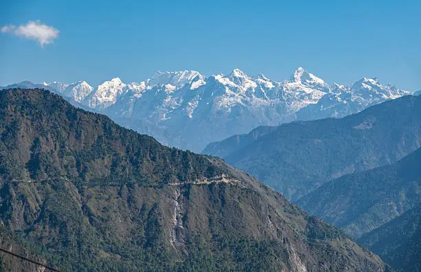
Overview of Ganesh Himal Trek
At a Glance
| Category | Details |
|---|---|
| Trek Duration | 14 Days |
| Maximum Elevation | 3,900 m / 12,795 ft (Ganesh Himal Base Camp) |
| Highest Pass | Pangsang La Pass (3,842 m / 12,605 ft) |
| Difficulty | Moderate to Challenging |
| Trek Type | Fully Camping (remote route), Tea House (partial routes) |
| Best Seasons | March to May and September to November |
| Starting Point | Syabrubesi or Gatlang (via Kathmandu) |
| Total Walking Distance | Approximately 90 to 110 km |
| Daily Walking Time | 5 to 7 hours on average |
| Group Size | Minimum 1, Maximum 16 (private groups welcome) |
| Permits Required | TIMS Card, Langtang National Park Entry Permit, Rasuwa Restricted Area Permit |
| Accommodation | Tents / Teahouses / Homestays, depending on the route section |
Best Time to Trek Ganesh Himal Base Camp
Nepal’s trekking seasons are defined by the monsoon, which runs roughly from mid-June through September, and the winter, which makes high passes difficult or impassable from December through February. Within those constraints, the Ganesh Himal trek offers two main windows of ideal conditions.
Spring Season: March to May
Spring is many experienced trekkers’ preferred season for the Ganesh Himal route. The rhododendron forests, which cover large sections of the trail between 2,000 and 3,500 meters, are in full bloom from late March through April, and the visual effect of walking through tunnels of deep red and pink rhododendron against a backdrop of snow-covered peaks is something genuinely difficult to describe without resorting to superlatives.
The temperatures are warming but not yet hot at lower elevations, and the higher passes are increasingly accessible as the snowpack from winter thins.
The main drawback of spring trekking is that the skies are not always as clear as in autumn: haze can build up during the day, particularly by late April and May, reducing the mountain views. The pre-monsoon thunderstorms can also be dramatic, though they generally arrive in the afternoon, giving morning walkers clear conditions. Trail conditions are generally excellent by mid-April.
Autumn Season: September to November
The period immediately following the monsoon, from late September through November, offers the clearest mountain views of the year. The monsoon rains wash the atmosphere clean, and the visibility in October, particularly, can be extraordinary, with mountain views extending far beyond what spring haze allows.
The rhododendron forests are not in bloom, but the landscape has its own beauty: rich greens in the lower forests, golden meadow grasses at altitude, and the particular quality of autumn light in the Himalayas that photographers consistently describe as the best of the year.
October and November see more trekkers on the popular routes in Nepal than any other months, though the Ganesh Himal trail remains significantly quieter than the Everest or Annapurna circuits even during the peak autumn season.
Temperatures become increasingly cold at altitude through November, and by late November, the higher passes can be challenging.
Seasons to Avoid
The monsoon season from mid-June through September brings heavy rainfall, leeches on the lower trail sections, significantly increased risk of landslides on the mountain roads, and poor visibility for mountain views.
While some hardy trekkers do undertake high-altitude routes during the monsoon and experience dramatic landscapes and green forests, it is not recommended for first-timers on the Ganesh Himal route due to the remoteness of the terrain and the challenges of the camp conditions in wet weather.
Winter months from December through February bring very cold temperatures and snow on the passes.
Tipping Guidelines
Tipping is a significant part of the income for guides and porters in Nepal’s trekking industry, where base salaries reflect the permit-based pricing of organized treks rather than the full market value of highly skilled professionals. The following are standard guidelines rather than fixed amounts, and should reflect your experience.
| Role | Recommended Tip |
|---|---|
| Lead Guide | USD 15 to 25 per day of the trek (total, to be given at the end) |
| Assistant Guide | USD 10 to 15 per day of the trek |
| Porter (per porter) | USD 8 to 12 per day of the trek |
| Camp Cook | USD 10 to 15 per day of the trek |
| Timing | Tip at the end of the trek in Kathmandu, in cash (Nepali rupees or US dollars both fine) |
| Presentation | Tipping in an envelope with a brief thank-you note is greatly appreciated |
Responsible Trekking in the Ganesh Himal Region
The communities and ecosystems you pass through on this trek are fragile in ways that are not always visible. The Ganesh Himal region has largely escaped the environmental damage that high-traffic trekking has brought to areas like the Everest corridor, and it is worth making deliberate choices to keep it that way.
- Carry all non-biodegradable waste out of the mountains. Do not leave any litter on the trail or at campsites, including food packaging, batteries, and plastic bottles.
- Use a reusable water bottle and purification tablets or a filter rather than buying single-use plastic bottles, which are available in village shops but create significant waste management problems.
- Respect the wildlife. Do not approach animals closely, do not feed them, and keep noise levels low in forested areas where wildlife sightings are possible.
- Be thoughtful about photographing local people. Ask before taking photographs, respect it when people decline, and do not offer money for photos, as this distorts social dynamics in communities along the trail.
- Support the local economy by buying food, drinks, and handicrafts in village shops and teahouses rather than bringing everything from Kathmandu. The economic benefit of trekking is most meaningful when it reaches the people living along the route.
- Learn a few phrases in Nepali: namaste (hello), dhanyabad (thank you), and ramro (beautiful/good) go a long way in village interactions. The effort is appreciated even when the pronunciation is imperfect.
- Follow the Leave No Trace principles at campsites: leave the site as you found it or better, use the designated toilet tent provided by your operator, and ensure all fires are fully extinguished.
About the Ganesh Himal Region
The Ganesh Himal massif takes its name from the Hindu deity Ganesha, the elephant-headed god associated with new beginnings, wisdom, and the removal of obstacles. The mountain’s profile, visible from multiple angles along the trek, does bear a resemblance to the seated figure of the deity, and for Hindus throughout South Asia, the mountain carries a spiritual weight beyond its physical scale.
The local Tibetan-origin name, Yangra, reflects the Buddhist cultural landscape through which the trek also passes. The Tamang people who inhabit these valleys have maintained a culture that draws from both Tibetan Buddhist traditions and the broader South Asian Hindu world, and the villages along the Ganesh Himal route are among the richest examples of this cultural synthesis in Nepal.
The Tamang Heritage Trail, which passes through Gatlang and other communities near the start of this trek, was partly established to make this cultural landscape more accessible to trekkers while channeling economic benefit directly to the communities.
The Ruby Valley, which gives this trek its alternative name, is one of only a handful of places in the world where rubies and corundum gemstones occur naturally in the ground. Local people have mined these stones for generations, and the mining activity continues today, largely through small-scale artisanal extraction.
Along sections of the trail, you may encounter miners returning from the high valleys, and occasionally, traders with small collections of stones for sale. The ruby deposits here are geologically ancient, formed by the same tectonic collision that created the Himalayas themselves.
The biodiversity of the region is exceptional even by Nepal’s high standards. The corridor between Langtang National Park and the Manaslu Conservation Area, through which this trek passes, functions as a wildlife movement corridor for several large mammal species, including the snow leopard, which inhabits the highest terrain.
Red panda populations in this region are among the healthiest in Nepal, and the diversity of birdlife, including several endemic and rare Himalayan species, makes this route valuable for birdwatchers.
In late spring and early summer, the meadows above 3,000 meters are rich with wildflowers and medicinal herbs, including the highly prized caterpillar fungus.
Learn more on our Manaslu Region page, and read our Langtang Region and Trek Preparation Guide before you go.
Elevation Profile
| Day | Location | Elevation | Distance | Walking Time |
|---|---|---|---|---|
| 1 | Arughat | 610 m | Drive + short walk | Arrival |
| 2 | Sotikhola | 700 m | ~14 km | 5–6 hrs |
| 3 | Machha Khola | 900 m | ~14 km | 5–6 hrs |
| 4 | Lapubesi | 1,120 m | ~15 km | 5–6 hrs |
| 5 | Chhokangparo | 3,010 m | ~16 km | 6–7 hrs |
| 6 | Chhule | 3,350 m | ~10 km | 4–5 hrs |
| 7 | Punkha Danda | 3,800 m | ~10 km | 5–6 hrs |
| 8 | Base Camp & Return | 4,900 m | ~16 km return | 7–8 hrs |
| 9 | Chhule | 3,350 m | ~10 km | 4–5 hrs |
| 10 | Chhokangparo | 3,010 m | ~10 km | 4 hrs |
| 11 | Lapubesi | 1,120 m | ~16 km | 6–7 hrs |
| 12 | Arughat | 610 m | ~15 km | 5–6 hrs |
| 13 | Kathmandu | 1,335 m | Road journey | 7–8 hrs drive |
| 14 | Departure | — | — | — |
- Reach Ganesh Himal Base Camp (4,900m) beneath Ganesh I (Yangra, 7,422m)
- Trek through pristine Tamang villages, little affected by mass tourism
- Spectacular panoramic views of Ganesh Himal, Langtang, and Manaslu ranges
- Extensive rhododendron and oak forests — exceptional birding
- Classic teahouse trekking with an off-the-beaten-path feel
- Combined cultural and natural experience in the Rasuwa district
Itinerary of Ganesh Himal Trek
Day 1: Drive Kathmandu to Trishuli — Trek to Arughat (610m)
You leave Kathmandu early, before the traffic builds, and drive northwest along the Trisuli River corridor. The road is familiar to anyone who has driven toward Langtang or Manaslu — market towns giving way to rice terraces, then the river gorge opening up in earnest as you push north. Trishuli Bazaar, a busy and entirely unpretentious town, is where many groups make a tea stop.
From the road’s end, you begin walking. The trail toward Arughat follows the Buri Gandaki river through subtropical forest and the first of the Tamang farming settlements that will become a recurring part of this journey’s texture. Arughat itself is a modest riverside town, but it marks the real beginning of things: the mountains you can see on the northern horizon are the ones you are walking toward. Camp is set up as the light fades and the river makes the kind of sound that makes sleeping easy.
Accommodation: Teahouse or tented camp in Arughat | Meals: Breakfast, Lunch, Dinner
Duration
Drive + 2 hrsActivity
TrekkingAccommodation
TeahouseMeals
L/DMax Altitude
610mDay 2: Arughat to Sotikhola (700m)
The Buri Gandaki becomes your companion and your compass today. The trail hugs its western bank through subtropical forest, the air still warm and dense at this elevation, the canopy loud with birds. The river here is wide and clear and moves with the particular authority of mountain rivers that have been gathering volume from a dozen tributaries above. You cross it several times on suspension bridges that sway gently under your feet.
The villages you pass through are small Tamang farming communities where the arrival of trekkers is still, if not exactly a novelty, at least something worth a second look from the doorway. Children appear from nowhere and follow at a short distance. Old women spin wool as they watch you walk past. By the time you reach Sotikhola in the late afternoon, the subtropical heat has been worth the effort: the camp sits beside a clear tributary stream, and the first hint of altitude has done nothing yet except make the cold water taste extraordinary.
Accommodation: Tented camp | Meals: Breakfast, Lunch, Dinner
Duration
5-6 hrsActivity
TrekkingAccommodation
TeahouseMeals
B/L/DMax Altitude
700mDay 3: Sotikhola to Machha Khola (900m)
Today continues the river-walking pattern that defines the lower section of this route. The Buri Gandaki alternates between wide, easy-walking sections and narrow gorges where the trail must climb above the water and pick its way across rocky faces. There are more river crossings today, some on bridges, some on stones, and the trail is well-enough used by local people and pack animals that route-finding is rarely in doubt.
The forest thickens and thins in cycles as the trail moves through different aspects of the valley. Dense sections of subtropical broadleaf give way to open rocky stretches with wide river views, then close in again. The birdlife is exceptional throughout. Machha Khola — the name simply means ‘fish river’ — is a larger settlement than yesterday’s camps, with a small collection of teahouses and a suspension bridge that you will use tomorrow morning.
Accommodation: Teahouse or tented camp | Meals: Breakfast, Lunch, Dinner
Duration
5-6 hrsActivity
TrekkingAccommodation
TeahouseMeals
B/L/DMax Altitude
900mDay 4: Machha Khola to Lapubesi (1,120m)
The valley begins to reveal its larger ambitions today. The walls on either side have been closing in gradually since Arughat, and now the Buri Gandaki moves with more force and less room to maneuver. The trail climbs and drops with the terrain, occasionally gaining significant elevation to avoid a cliff section before descending again to river level. Your legs are finding their rhythm by now, and the daily walking feels less like effort and more like movement.
The villages along this stretch are predominantly Tamang and Gurung, and the architecture shifts subtly as you move north — stone and slate increasingly replacing the mud-plaster walls of the lower valley, carved wooden window frames appearing on the better-maintained houses. Lapubesi sits at a point where the valley widens slightly before narrowing again for its final push toward the high country. The evenings here are cooler, and the stars, if the sky is clear, are beginning to have the depth that altitude gives them.
Accommodation: Teahouse or tented camp | Meals: Breakfast, Lunch, Dinner
Duration
5-6 hrsActivity
TrekkingAccommodation
TeahouseMeals
B/L/DMax Altitude
1120mDay 5: Lapubesi to Tsum Valley Junction — Trek to Chhokangparo (3,010m)
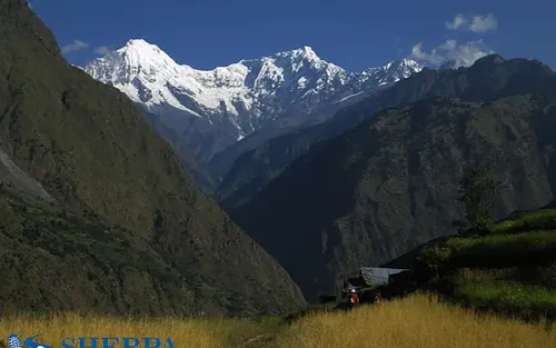
Today is the day the landscape changes its mind entirely. You leave the Buri Gandaki corridor and turn into the approach valley for Ganesh Himal, and the altitude increases with a seriousness that makes itself known in your breathing somewhere above 2,500 meters. This is not a crisis, just a reminder that you are in Nepal and the mountains here mean business.
The trail climbs through rhododendron and juniper forest, the trees growing increasingly twisted and atmospheric as you gain height. In spring, the rhododendrons are doing their annual performance — great cascades of deep crimson and pale pink above the forest floor — and the contrast with the snow-covered ridges visible above the treeline is one of those images that trekking in Nepal delivers without warning and that you find yourself returning to for weeks afterward.
Chhokangparo, at 3,010 meters, is a high-altitude pastoral settlement where yak herders spend the summer months. The camp here is open, and the Ganesh Himal peaks, visible for the first time properly today, command the northern skyline in a way that makes it difficult to look at anything else. Drink plenty of water tonight and go to bed earlier than feels necessary.
Accommodation: Tented camp | Meals: Breakfast, Lunch, Dinner
Duration
6-7 hrsActivity
TrekkingAccommodation
TeahouseMeals
B/L/DMax Altitude
3010mDay 6: Chhokangparo to Chhule (3,350m)
This is an acclimatization day in the sense that you are still gaining altitude, but at a pace designed to give your body a reasonable chance to adjust. The trail moves through high-altitude meadows where the grass is short and wiry, and the light has that sharp, slightly unfiltered quality that altitude gives to everything. Yak herding communities dot the upper pastures; you may pass through a temporary herder’s settlement and be offered butter tea from a doorway.
The views of the Ganesh Himal peaks continue to improve as you climb — Ganesh I’s south face increasingly fills the northern horizon, and the subsidiary peaks of the massif spread to either side like attendants. Chhule at 3,350 meters is a beautiful campsite, and tonight will be genuinely cold. This is the moment to locate your warm layers before you need them, not after.
Accommodation: Tented camp | Meals: Breakfast, Lunch, Dinner
Duration
5-6 hrsActivity
TrekkingAccommodation
TeahouseMeals
B/L/DMax Altitude
3350mDay 7: Chhule to Punkha Danda (3,800m)
The final push to the high ridge camp. The trail today crosses increasingly open terrain — the trees have given way entirely to alpine meadow and rock, and the wind, when it picks up in the afternoon, is cold and carries the smell of ice from the glaciers above. Your pace may be slower than usual, and that is exactly right; this is the altitude talking, asking you to move with more deliberateness.
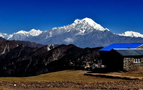
Punkha Danda is a ridge camp with a view that justifies the climb several times over. The panorama from the campsite takes in Ganesh I, II, III, and IV across the northern horizon, with the Langtang range visible to the east and Manaslu’s distinctive profile to the west. Prayer flags may have been strung here by previous expeditions, and they catch the wind with that particular urgency that flags only have at altitude. Camp tonight will be cold in earnest — layers on before you stop moving, and a water bottle in your sleeping bag.
Accommodation: Tented camp | Meals: Breakfast, Lunch, Dinner
Duration
4-5 hrsActivity
TrekkingAccommodation
CampMeals
B/L/DMax Altitude
3800mDay 8: Punkha Danda to Ganesh Himal Base Camp (4,900m) and Return
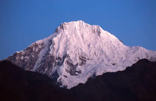
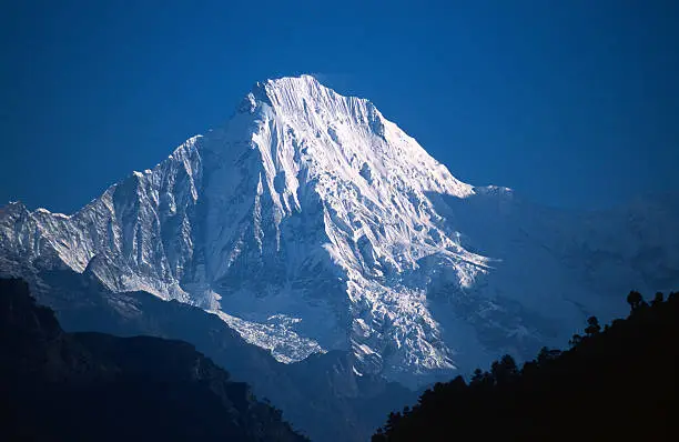
This is the day you have been walking toward. Leave camp after an early breakfast and move steadily upward through the final section of alpine terrain. The landscape here is high and severe and beautiful in the way that landscapes are when they have been shaped entirely by ice, wind, and time, with no human hand in it. The glacial basin that houses the base camp opens up without warning, and the mountain — Ganesh I, Yangra, 7,422 meters — stands above it in a way that makes you stop walking and simply look.
The base camp sits beneath the massive south face of the peak, surrounded by moraines and the lower sections of the glacier. The scale of the mountain at close range is something that photographs do not communicate; you understand here, in a way that maps and elevations do not convey, what it means for a place to be genuinely high and genuinely remote.
Take as much time as you need. Study the mountain, walk to the glacier edge, sit by whatever melt pool is accessible, and let the altitude and the silence do what they do. The return to Punkha Danda retraces the morning’s route and will feel shorter in the way that downhill always does.
Accommodation: Tented camp at Punkha Danda | Meals: Breakfast, Lunch, Dinner
Duration
6-7 hrsActivity
TrekkingAccommodation
CampMeals
B/L/DMax Altitude
4900mDay 9: Punkha Danda to Chhule
The descent always has a different emotional register than the climb. The sense of anticipation that pulled you upward is replaced by something more contemplative — a reviewing of what you have seen, a noticing of things that effort and altitude made you pass too quickly on the way up. The views from this ridge look entirely different when you are facing south, and the light in the afternoon has a quality that the morning did not.
Walking downhill is physically less demanding on the lungs but more honest about your knees. Take care of any loose sections and let the terrain set the pace rather than the knowledge that it is all downhill from here. The camp at Chhule will feel almost warm after the nights at Punkha Danda, and the mood tends toward the celebratory.
Accommodation: Tented camp | Meals: Breakfast, Lunch, Dinner
Duration
4-5 hrsActivity
TrekkingAccommodation
TeahouseMeals
B/L/DMax Altitude
3350mDay 10: Chhule to Chhokangparo
A straightforward descent through the terrain that seemed so demanding a few days ago and now feels almost gentle. The rhododendron forest, if you are here in spring, rewards a second look from the opposite direction. The Ganesh Himal peaks behind you are now framed differently — you have been to their foot and back — and that changes the way they look in a way that is difficult to articulate but easy to feel.
Chhokangparo, for the second time, feels like a familiar place, which it is not quite, but almost. The yak herders, if the same ones are still here, may recognise your guide. The evening is quieter than usual; long treks tend to produce a particular kind of companionable silence in the final days that is its own form of conversation.
Accommodation: Tented camp | Meals: Breakfast, Lunch, Dinner
Duration
4-5 hrsActivity
TrekkingAccommodation
TeahouseMeals
B/L/DMax Altitude
3010mDay 11: Chhokangparo to Lapubesi
The long return to the lower valley. The trail drops back through the forest and the Tsum Valley junction and rejoins the Buri Gandaki corridor with its familiar warmth and sound and density of vegetation. The air at 1,100 meters is noticeably thicker than it was four days ago at the ridge, and your body registers the oxygen as a pleasant surplus.
The villages along this stretch are worth more attention on the return than they received on the way up, when the pull of the high country was making you look forward rather than around. Stop at a teahouse if there is one open, drink tea, watch the river, and talk to your guide about what you have just done.
Accommodation: Teahouse or tented camp | Meals: Breakfast, Lunch, Dinner
Duration
6-7 hrsActivity
TrekkingAccommodation
TeahouseMeals
B/L/DMax Altitude
1120mDay 12: Lapubesi to Arughat
The final day of trekking retraces the lower river route and has a different quality than any of the days that preceded it. The sense of completion is present but not yet dominant — you are still walking, still in the mountains, still part of the journey. The Buri Gandaki, which you have followed north for the past week and change, is now carrying you south toward the roads and the cities.
The communities along the way — the same Tamang farming villages, the same children at school gates, the same suspension bridges — are saying goodbye in the way landscapes do, by looking familiar and slightly unreal at the same time. Arughat, when you reach it, marks the end of the walking. The mountains are still visible to the north. They will be visible for a long time after this.
Accommodation: Teahouse or tented camp | Meals: Breakfast, Lunch, Dinner
Duration
5-6 hrsActivity
TrekkingAccommodation
TeahouseMeals
B/L/DMax Altitude
610mDay 13: Drive Arughat to Kathmandu
The vehicle meets you at Arughat, and the journey south begins. The Trisuli river corridor, which you drove through in the other direction on Day 1, unspools in reverse through the windows: gorge country, then market towns, then the Kathmandu Valley widening out ahead. You will see it differently now, carrying the weight of what you have walked through and the height you have been.
Kathmandu, when it comes, comes in its usual gradual-then-all-at-once way. The first mobile signal. The first traffic jam. The first restaurant menu with more than five items. A hot shower and a meal that someone else cooked while you sat down for it feel, after two weeks in the mountains, like genuine luxuries. Sleep when you are ready. You have earned it.
Accommodation: 3-star hotel in Kathmandu | Meals: Breakfast, Farewell Dinner
Duration
DriveActivity
TravelAccommodation
HotelMeals
BMax Altitude
1400mDay 14: Final Departure
Depending on your flight time, the morning may be free for a last walk through Thamel, a final cup of coffee in one of the rooftop places with a view of the street, or simply sitting with your pack and thinking about what just happened. Your trekking company will arrange an airport transfer at the appropriate time.
The mountains you have been visiting will not be visible from Tribhuvan International Airport. They rarely are from the city. But you will know they are there, to the north, exactly where you left them.
Meals: Breakfast
Duration
DepartureActivity
TransferAccommodation
HotelMeals
BMax Altitude
1400mIncludes/Excludes
What's included?
- 13 nights accommodation (2 hotel Kathmandu, 11 teahouse/camping)
- All ground transport Kathmandu–trailhead and return
- All meals on trek
- Licensed English-speaking guide and porter
- Langtang National Park permit, TIMS card
- First-aid kit and emergency protocols
What's not included?
- International airfare and Nepal visa fees
- Travel and medical insurance (recommended)
- Personal gear and clothing
- Tips for guide and porter
- Beverages and personal snacks
Ganesh Himal Trek Altitude Chart
Trip Information - Good to Know
Permits and Paperwork
The Ganesh Himal trek passes through areas requiring several different permits, and your trekking company will arrange all of these on your behalf as part of the package. It is, however, useful to understand what you are carrying and why.
TIMS Card
Trekkers Information Management System card. Required for all trekkers in Nepal. Cost approximately USD 10-20, depending on group or individual arrangement.
Langtang National Park Entry Permit
Required for entry into the national park area through which part of the route passes. Cost approximately NPR 3,000 (approx. USD 22) for foreign nationals.
Rasuwa District Permit
Local permit for trekking in the Rasuwa district, which encompasses the Ganesh Himal region. Your operator handles this.
Where to Get Permits
All permits can be obtained in Kathmandu at the Nepal Tourism Board office in Bhrikuti Mandap. Your trekking company will handle the process, but you will need two passport photos and a photocopy of your passport for each permit.
Altitude, Health, and Safety
The Ganesh Himal Base Camp trek reaches a maximum elevation of 3,900 meters, which is well within the range where altitude sickness can affect people, though it is lower than many other Himalayan treks that push above 5,000 meters. The key principle of high-altitude trekking is simple to state and sometimes difficult to follow in practice: ascend slowly, listen to your body, and never let pride or peer pressure override your physical reality.
Acute Mountain Sickness (AMS)
AMS is the most common altitude-related health concern and can affect anyone, regardless of physical fitness. The symptoms, which include headache, nausea, dizziness, fatigue, and difficulty sleeping, are the body’s response to the reduced oxygen availability at altitude. Mild AMS is common and generally resolves within a day or two if you stop ascending. The important rule is: if symptoms are moderate to severe, or if they are not improving, descend. This trek’s itinerary is designed to allow adequate acclimatization, but every individual responds to altitude differently.
Diamox (acetazolamide) is widely used to prevent and treat AMS. It works by stimulating breathing, which helps the body acclimatize faster. Consult your doctor before the trip about whether it is appropriate for you, what dose to take, and what side effects to expect (tingling in the fingers and toes is common and harmless). It is available at pharmacies in Kathmandu if you did not bring it from home.
Practical Health Tips
- Drink at least 3 to 4 liters of water per day while trekking at altitude
- Avoid alcohol, especially for the first few days at altitude and before nights at high camp
- Walk at a pace that allows you to hold a conversation without gasping
- If you develop a headache, take it seriously: rest, hydrate, and consider your options
- Never ascend to sleep at a higher elevation if you have symptoms of AMS
- The guides carry a pulse oximeter and will check your oxygen saturation regularly at altitude
- Emergency evacuation by helicopter is available from most points on this route, and is covered by travel insurance that includes high-altitude coverage.
Gear and Packing List
The Ganesh Himal trek requires thoughtful packing. You need to be prepared for cold high-altitude nights and warm lower-elevation days within the same trip, and the remote nature of much of the route means you cannot count on restocking or purchasing forgotten items mid-trek. The list below is comprehensive, but every item listed has earned its place.
Clothing
- Moisture-wicking base layer tops (2 to 3 sets)
- Thermal or merino wool base layer bottoms
- Mid-layer fleece jacket or softshell
- Down jacket (essential for evenings above 3,000 m)
- Waterproof outer shell jacket (Gore-Tex or equivalent)
- Waterproof trousers or rain pants
- Trekking trousers (2 pairs, zip-off style ideal)
- Warm trekking socks (4 to 5 pairs, wool preferred)
- Lightweight liner socks
- Warm hat or beanie covering ears
- Sun hat or broad-brimmed hat for lower elevations
- Lightweight gloves and one pair of warm or waterproof gloves
- Gaiters (useful in wet conditions and on high passes)
- Camp shoes or lightweight sandals
Footwear
- Broken-in waterproof trekking boots with ankle support (this is the single most important gear item on this list)
- A second pair of comfortable walking shoes for easier trail sections
Equipment
- Trekking poles with rubber tips (invaluable on descents)
- Daypack (25 to 35 liters) for carrying items you need during the walking day
- Sleeping bag rated to at least minus 10 degrees Celsius
- Headlamp with spare batteries
- Water bottles (2 liters total capacity) or hydration bladder
- Water purification tablets or a portable filter
- Sunglasses with UV protection (polarized lenses are highly recommended at altitude)
- High-factor sunscreen (SPF 50 minimum) and lip balm with SPF
- Small camera or smartphone with sufficient storage and a spare battery/power bank
- Lightweight towel
- Trekking map (provided by operator) and compass
First Aid and Personal Health
- Personal first aid kit, including blister treatment
- Diamox (acetazolamide) for altitude sickness prevention (consult doctor before departure)
- Ibuprofen or paracetamol for pain and headache
- Antidiarrheal medication
- Oral rehydration salts
- Insect repellent for lower elevations
- Hand sanitizer
- Prescription medications in sufficient supply, plus extra for delays
Frequently Asked Questions
Is Ganesh Himal as crowded as Langtang?
No — Ganesh Himal receives a fraction of Langtang’s trekker numbers. You will rarely meet other trekking groups above the lower valley.
Does this trek require a special permit?
No restricted area permit is required. The standard Langtang National Park entry permit (NPR 3,000) and TIMS card cover this route.
Is camping required?
Teahouses are available through most of the route. Camping is used for the high base camp approach above Punkha Danda where teahouse infrastructure is absent.
What cultural groups live in this region?
The Ganesh Himal area is home to Tamang and Gurung communities in the lower valleys, and Tibetan-influenced Nubri communities in the upper sections near the Nepal-Tibet border.
How does the altitude affect the trek?
Maximum altitude is ~4,900m at base camp. The ascent from the lower valleys is gradual enough for adequate acclimatisation, but walkers should rest if experiencing altitude symptoms.
Can this trek be combined with Manaslu Circuit?
Yes — the Buri Gandaki approach is shared with the Manaslu Circuit start. With additional time, a combined itinerary is possible for experienced trekkers.
Trip Reviews
- Best Price Guarantee
- Secure & easy booking
- Easy trip date changes
- Discount for groups


How to book a trip?

make free inquiry

confirm the trip