

Upper Mustang Trek


Trip Duration
18 days DaysGroup Sizes
Min 2.pax PeopleTransportation
DriveDestination
Upper Mustang TrekMax. Altitude
3840Nature of Trip
Trekking,DrivingBest Season
Sep-Dec,Mar-MayDifficulty
ModerateMeals
- Breakfast
- Lunch
- Dinner
Start & End Point
Kathmandu/PokharaAccommodation
- Hotel
- Lodge
- Teahouse
Overview of Upper Mustang Trek
|
 |
Before You Go: What This Trip Actually Is
Let’s be straight about what Upper Mustang is and isn’t. It isn’t comfortable. Teahouse mattresses are thin, nights get genuinely cold even in April, the wind between Jomsom and Lo Manthang will push you sideways on exposed ridges, and some days you’ll walk six or seven hours to reach a village with one guesthouse and a menu of exactly three items. That’s not a complaint. That’s precisely what makes this place unlike anywhere else you’re likely to travel in your lifetime.
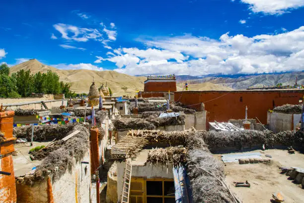
Upper Mustang sits in the rain shadow of the Annapurna and Dhaulagiri ranges in northwestern Nepal, far enough north that the monsoon can’t really reach it. The landscape is the kind that makes you stop mid-stride just to look around. Ochre cliffs riddled with ancient caves, eroded canyons in shades of deep red and purple, the occasional chorten standing alone on a ridgeline with nothing but sky behind it. Lo Manthang, the old walled capital of the Kingdom of Lo, has been standing since around 1380 CE and looks like it hasn’t had much reason to change since.
This guide is for the overland traveller. You go by road from Kathmandu through Pokhara and up the Kali Gandaki gorge to Jomsom, then on foot into the restricted zone. It takes longer than flying. It’s also a far better way to arrive, because the landscape shifts so gradually and so unmistakably that by the time you reach Kagbeni, you already understand something about where you are. The flight drops you in the cold. The road earns you the entrance.
Everything you need is here: the permits and how to get them without losing days to queues, the full day-by-day route with honest notes on what each section is actually like, what things cost, how to behave respectfully in Tibetan Buddhist communities, and what to do when something goes sideways. Read it carefully before you leave Kathmandu. Some of the details only matter once it’s too late to address them.
About Upper Mustang
The Landscape
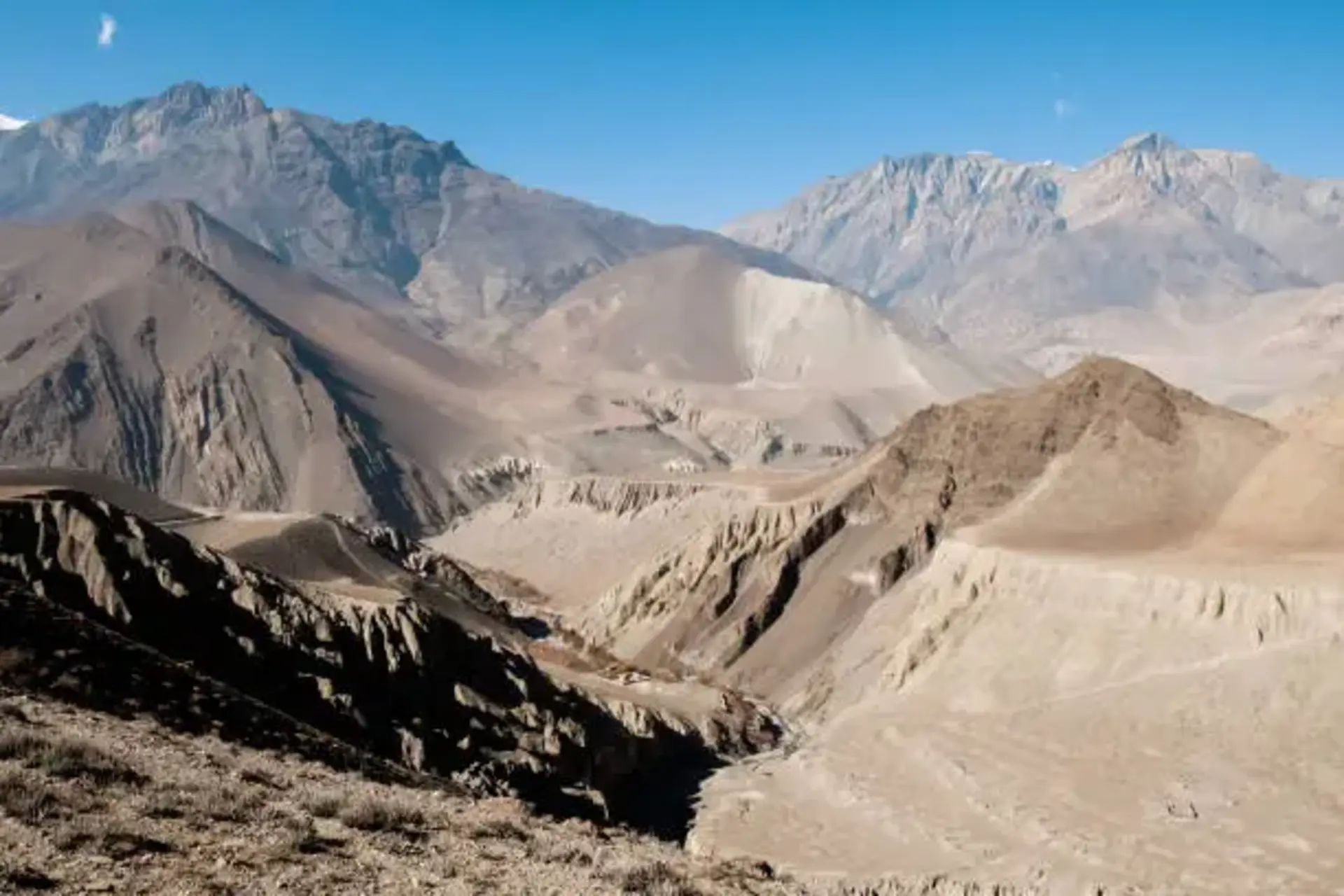
Upper Mustang is in Gandaki Province and shares its northern border with Tibet. The Himalayas block almost all monsoon moisture from reaching this far, keeping annual rainfall under 300mm, less than many deserts. What that produces on the ground is a landscape that looks more like parts of the American Southwest or central Tibet than anything you pass through in the green hills south of Pokhara. The cliffs are enormous and carved into strange forms by centuries of wind erosion. Many of them are honeycombed with caves, some natural, many dug and modified by communities whose origins archaeologists are still piecing together.
Lo Manthang sits at 3,840 metres in a wide flat basin surrounded by barley and buckwheat fields fed by snowmelt irrigation channels. The walled city encloses around 150 to 200 permanent residents these days, four major monasteries, and the old royal palace. From certain angles on the approach from the south, it genuinely looks like a painting of a medieval settlement dropped into the middle of a plateau. The first time you see it, you’ll probably stop walking.
History and Culture
The Kingdom of Lo was founded in the late 14th century by a man called Ame Pal, who managed to bring the competing chieftains of the upper valley under one authority. Lo Manthang was built under his rule, and the kingdom sat on the ancient salt trade routes between Tibet and the Indian plains, which kept it economically relevant for centuries. The last king, Jigme Dorje Palbar Bista, held ceremonial status until 2008 when Nepal abolished its own monarchy. The formal recognition of Lo’s royal lineage ended with it, though the family’s cultural significance hasn’t really.
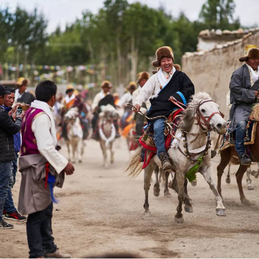
Culturally, this is a Tibetan Buddhist place. The language is a Tibetan dialect, the religion is Vajrayana Buddhism built over older Bon traditions, and the Tiji Festival held annually in late April or May is one of the most extraordinary religious events in the entire Himalayan world. Three days of masked dances, ritual music, and community ceremony in the courtyard of Lo Manthang. If you can plan your trip around it, do.
Permits: What You Need and How to Get Them
Upper Mustang is a restricted area. That designation is enforced, not ceremonial. You can’t cross the checkpoint at Kagbeni without the correct paperwork, and you cannot travel without a licensed Nepali guide at your side. Attempting to get around either of those requirements ends with a fine, a forced exit from the zone, and a very uncomfortable afternoon with district authorities. Plan the permit process before you even book flights.
Nepal Tourist Visa
You need a valid tourist visa before anything else applies. Most nationalities get this on arrival at Tribhuvan International Airport in Kathmandu.
- Fifteen days: USD 30
- Thirty days: USD 50
- Ninety days: USD 125
Indians don’t need one. Chinese nationals have a separate arrangement and should confirm with the Nepali consulate before travelling. The tourist visa just means you’re legally in Nepal. It gets you access to nothing restricted.
Restricted Area Permit (RAP)
This is the significant one.
- Cost: USD 500 per person (first 10 days)
- Additional days: USD 50 per person per day
It’s issued by the Department of Immigration in Kathmandu or through a registered trekking agency. The permit states exact entry and exit dates. There’s no informal extension in the field; if you want more days, you apply for them upfront.
Minimum group size is two people. Solo travellers need a special exemption, which your agency can sort out, but it needs to be arranged in advance.
Details:
- Issued By: Department of Immigration, Kathmandu, or licensed agency
- Documents Needed: Passport copy, Nepal visa copy, 2 passport photos, payment in USD or NPR
- Processing Time: 1–3 working days minimum (longer in peak seasons)
- Solo Travellers: Require advance exemption
Annapurna Conservation Area Permit (ACAP)
Everyone entering the Mustang region needs this, too. It covers the protected area that the approach routes pass through. Costs NPR 3,000 per person. Pick it up at the ACAP office in Pokhara rather than dealing with the queue at the Jomsom checkpoint. Takes ten minutes in Pokhara and saves an aggravating delay at the start of the trek.
TIMS Card
The Trekkers’ Information Management System card is required for all trekkers in Nepal. Since a licensed agency is mandatory for Upper Mustang anyway, you’ll get the group TIMS through them at NPR 500 per person. The card registers your details with the authorities. It actually matters in an emergency, so don’t treat it as bureaucratic box-ticking.
Getting the Permits Without Losing Your Mind
Email a Kathmandu-based registered trekking agency a week or two before you arrive with your passport details, intended dates, and itinerary. They’ll handle the RAP, ACAP, and TIMS simultaneously and have everything ready when you land. This is by far the cleanest approach and avoids standing in separate queues at multiple government offices during your first two days in the city.
If you’d rather apply independently, the Department of Immigration is on Kalikasthan Marg in the Naxal area of Kathmandu. Come early, bring originals and photocopies of everything, and don’t expect speed during March, April, or October. Either way, every permit needs to be physically in your hands before you get on anything heading north.
The Road North: Kathmandu to Jomsom
People underestimate this drive. The Kali Gandaki gorge section alone is worth a trip on its own, independently of whatever awaits in the restricted zone. The road isn’t always smooth, and in monsoon transition months, it gets complicated by landslides, but the landscape is extraordinary, and the gradual altitude gain gives your body a useful introduction to what’s coming before the actual trekking starts.
Kathmandu to Pokhara
About 200 kilometres along the Prithvi Highway. Tourist buses take six to eight hours and leave from Kantipath or Thamel in the early morning. A private vehicle cuts it to five or six hours and lets you stop where you want, which matters along the Trisuli River section, where the gorge views are worth twenty minutes. Bus fare runs NPR 600 to 1,200, depending on the service. Private hire is NPR 8,000 to 14,000 one way.
Give Pokhara at least one full day. You need to finalise permits there, withdraw the last cash you’ll have access to for the next two weeks (there are no ATMs north of Jomsom and teahouses are cash-only without exception), meet your guide properly, and pick up any remaining gear or medications. Prices fall sharply once you leave Pokhara, and availability falls further than that.
Pokhara to Beni
The road north follows the Kali Gandaki River. Beni, headquarters of Myagdi District, is about 70 kilometres away and two to three hours on a paved road. It’s a busy market town and the last real place to pick up anything you’ve forgotten. Worth a lunch stop. After Beni, the road enters the gorge, and the whole character of the journey shifts.
Beni to Tatopani
This is where the drive stops being a journey between places and becomes the journey. The Kali Gandaki gorge is among the deepest on earth, and the road runs right through it, squeezed between the river and vertical rock walls. There are sections where it’s one vehicle wide, and you hear the river below before you see it. Tatopani is about two hours from Beni. It’s famous for its hot springs, which emerge at the riverbank and have been collected into concrete pools. Soaking in them at the end of a day on mountain roads is one of those experiences that’s simple and exactly as good as it sounds.
Tatopani to Marpha and Jomsom
North of Tatopani, the road climbs through Ghasa and Lete, and the vegetation begins to thin. Juniper replaces the bamboo. The air gets drier. By the time Marpha appears, about three to four hours from Tatopani, you’re in a different climate entirely.
Marpha is a beautiful, compact village, with whitewashed stone houses connected by covered alleyways built specifically to give residents some shelter from the afternoon wind. It’s famous for its apple orchards and for the brandy and cider made from them. Stay overnight if your schedule allows it. From Marpha it’s 7 kilometres and half an hour to Jomsom.
Jomsom is the district headquarters at 2,720 metres. Functional, wind-battered, with a good bazaar and several guesthouses. The valley here is notorious for its afternoon winds, which start around midday and peak by early afternoon. Clear mornings give you extraordinary views of the Nilgiri to the east.
Route Summary
- Kathmandu to Pokhara
200 km | 6–8 hrs by bus, 5–6 hrs by private vehicle - Pokhara to Beni
70 km | 2–3 hrs on paved road - Beni to Tatopani
Approx. 50 km | 2 hrs through the Kali Gandaki gorge - Tatopani to Marpha
Approx. 60 km | 3–4 hrs on rough mountain road - Marpha to Jomsom
7 km | 30 minutes
|
|
- Restricted region trekking experience with limited access and fewer crowds
- Unique trans-Himalayan landscape with red canyons, cliffs, and desert-like terrain
- Scenic overland journey through the Kali Gandaki Gorge, one of the deepest in the world
- Gradual transition from lush hills to dry high-altitude plateau
- Visit to Lo Manthang, a 15th-century walled city with rich history
- Strong Tibetan Buddhist culture and traditions throughout the region
- Ancient monasteries with murals, statues, and preserved heritage
- Opportunity to witness the Tiji Festival (seasonal cultural highlight)
- Authentic teahouse accommodation with local food and hospitality
- Daily changing landscapes offering diverse trekking experiences
- High mountain passes with panoramic views toward the Tibetan plateau
- Exploration of ancient cave systems carved into cliffs
- Interaction with local communities and traditional lifestyles
- Peaceful environment with minimal commercialization
- A challenging yet rewarding journey that feels truly earned
- Ideal for travelers seeking culture, remoteness, and raw natural beauty
Itinerary of Upper Mustang Trek
Day 1: Arrival in Kathmandu
Kathmandu hits you immediately and all at once. The traffic, the temples, the incense mixed with diesel, the Newari architecture sharing wall space with mobile phone shops and vegetable stalls. If your flight lands in the morning, don’t spend the afternoon in the hotel. Walk from Thamel down to Asan Tole and let the city be loud and overwhelming for a few hours. It is. That’s fine. You won’t be bored.
Evening: sit down with your agency contact for the pre-departure briefing. Confirm permit status, the road conditions between Tatopani and Marpha (this section is the one most likely to have had recent disruptions), guide assignment, and emergency contact details. Write the answers down. Get a dinner with a rooftop view if the sky cooperates and sleep early. The driving starts properly tomorrow.
Activity
RestAccommodation
HotelMax Altitude
1400mDay 2: Kathmandu: Permits and Preparation
Morning goes to permits. If your agency has handled everything, go to Boudhanath Stupa instead of sitting in government queues. The great white dome is the spiritual centre of Kathmandu’s Tibetan Buddhist community and one of the most genuinely affecting places in the city. Come early, before the tourist groups arrive, and walk the circumambulation path with the locals. Prayer wheels turning, monks chanting, juniper incense coming from the shrine rooms above. It gives you an immediate, felt sense of the Buddhist tradition you’re about to spend two weeks alongside, which is more useful than any amount of background reading.
Afternoon: Pashupatinath Temple on the Bagmati River, if you have time. The most significant Hindu temple in Nepal. As an outsider, you can’t enter the main grounds, but the stone ghats along the river, where cremation fires burn through the day, are open. Sit somewhere and watch for an hour without framing it for a photo. Then go back to your hotel and be seriously ruthless with your pack. Every kilo you carry from here will register at 3,800 metres.
Duration
Full dayActivity
Sightseeing,PreparationAccommodation
HotelMax Altitude
1400mDay 3: Kathmandu to Pokhara
Leave by 7 am. The Prithvi Highway carries serious freight traffic, and the first stretch out of Kathmandu is slow regardless of when you leave, but an early start means you clear the worst of it before the trucks multiply. Past Naubise and down into the Trisuli River valley, the road settles, and the mid-hill scenery opens up properly: layered terraces receding to the horizon, mustard-yellow in spring or heavy with millet in autumn.
The highway runs through Mugling, where two rivers meet, then west through Dumre and on to Pokhara. Arrive by early afternoon. Your guesthouse should be near Lakeside. That evening, walk the Phewa Lake promenade slowly. If the sky is clear, the Annapurna range turns from pale gold to pink to deep red as the sun goes down and Machhapuchhre reflects in the lake below it. Yes, it actually looks like a postcard. Some views just do. Get a decent dinner and a full night’s sleep.
Duration
6-8 hoursDistance
200 kmAccommodation
HotelMax Altitude
820mDay 4: Pokhara: Preparation Day
Don’t skip this or compress it into half a day. Pokhara is the last place where things can be fixed. North of here, if something’s wrong, the answer is usually that you go without it. Morning: check every permit physically. Names are spelled exactly as they appear in your passport—dates matching your planned entry and exit from the restricted zone. The zone is correctly described. Minor discrepancies get flagged at Kagbeni, and resolving them in the field is slow and unpleasant in an entirely avoidable way.
Then the ATM. Then probably the ATM again because single-withdrawal limits at Nepali ATMs are often lower than expected. Work out exactly what you need: accommodation every night of the trek, three meals a day, guide fees, porter fees if you’re using one, and an emergency buffer. Once you’ve calculated that number, add twenty percent. Running out of cash in Lo Manthang is a specific category of problem with no easy solution. Afternoon: Lakeside gear shops for anything missing from your kit. Then confirm the jeep departure time for tomorrow morning.
Activity
ATM, permits, supplies, guide meetingAccommodation
HotelMax Altitude
820mDay 5: Pokhara to Tatopani
Leave at first light. The jeep road north passes through Baglung and then Beni, where the transition from ordinary mountain highway to gorge road happens almost without warning. The valley walls close in, the road narrows, the river gets audible before it’s visible, and the air picks up the coolness of deep shade.
This section of the Kali Gandaki gorge deserves your full attention. Put the phone away.
Arriving in Tatopani by early afternoon leaves time to walk down to the hot springs before they get busy. The pools are right at the riverbank, simple concrete basins, and locals and trekkers end up in the same water with a democratic informality that feels genuinely Nepali. The water is reliably hot. The contrast with the mountain air above is excellent. Dinner at one of the nearby teahouses. Dal bhat is good here, and the local raksi, a rough distilled grain spirit, is worth a cautious try if you’re inclined. Sleep well.
Duration
4-5 hoursDistance
120 kmActivity
DriveAccommodation
TeahouseMax Altitude
1190mDay 6: Tatopani to Marpha
This drive is where the landscape changes for real. North of Ghasa, which takes about an hour from Tatopani, the subtropical forest starts thinning out. Fig and bamboo give way to pine and then juniper. The air dries noticeably. By the time the valley widens past Lete and Kokhethanti, you’re somewhere that has nothing to do with where you woke up this morning. The road crosses the river on suspension bridges that range from reassuringly solid to not quite that. The views toward Nilgiri are extraordinary at several points along this stretch.
Marpha is one of those places that earns its reputation. Compact whitewashed stone houses linked by covered lanes designed to provide shelter from the perpetual afternoon wind, apple orchards on both sides of the road, and a small Sakya monastery above the village. Walk the lanes before dinner. Visit the monastery if it’s open. The apple brandy here has a devoted following throughout Nepal for good reason. Try it. Overnight in Marpha, where the evenings are quiet, and the sky is extraordinarily clear.
Duration
3-4 hoursDistance
60 kmActivity
DriveMax Altitude
2670mDay 7: Marpha to Kagbeni via Jomsom
Half an hour from Marpha puts you in Jomsom. The district headquarters has a proper bazaar stocked with everything from cooking gas to basic medications, and this is your genuine last chance to address any supply gaps. The Mustang Eco Museum in the new town quarter gives an honest and informative overview of the region’s geology, culture, and history. Worth an hour before you enter the restricted zone. The context it provides makes what you see later significantly more legible.
Jomsom to Kagbeni is 7 kilometres. You can jeep it in under an hour or walk the riverside trail in about two and a half to three hours. The walk is flat and easy and gives you a first real taste of this landscape on foot, wide gravel bars, the river grey with glacial sediment, and the first dry-country vegetation of the trip.
Kagbeni is where your permit gets verified for the first time. Have everything accessible before you reach the checkpoint. The village beyond it is one of the most atmospheric in Nepal: mud-brick buildings, covered lanes, a towering red monastery at the confluence of two rivers. Spend the evening exploring before the light goes. Tomorrow the restricted zone begins.
Activity
Drive,TrekMax Altitude
2810mDay 8: Kagbeni to Chele
Day one inside the zone, and the landscape announces the change with no subtlety at all. The trail climbs out of the Kali Gandaki valley on steep switchbacks and enters a world that operates on completely different visual terms. The cliffs are enormous and honeycombed with caves. Some are natural geological features. Many were carved and modified by human hands, some going back two or three thousand years. What those cliff communities were doing up there, how large they were, what eventually happened to them, is something archaeologists are still working through. Your guide may have local oral traditions about them that are worth hearing alongside the scholarly uncertainty.
Tangbe, about an hour from Kagbeni, is a neat farming village, with whitewashed houses and patchwork fields of buckwheat and wheat against the raw landscape behind it. Worth slowing down for ten minutes. Chhusang further along sits at a river junction with its own ancient cave complex in the surrounding cliffs. Chele at 3,050 metres has a few teahouses and a monastery on the slope above. The altitude gain today is manageable but real. Drink through the day, eat a proper dinner, and pay attention to how you sleep. AMS usually shows up at night before it affects you during the day.
Duration
5-6 hoursDistance
14 kmActivity
TrekMax Altitude
3050mDay 9: Chele to Syangboche via Samar
The hardest day on the northbound route and, honestly, one of the best. Two high passes, a descent into forested gullies that feel incongruously lush in this dry landscape, and a long climb to Syangboche. Start early. The afternoon wind makes the exposed ridges unpleasant. Carry more water than feels necessary and eat on the move at the passes because stopping for a full meal at altitude and wind isn’t practical.
The first climb reaches the Taklam La at around 3,624 metres. The view north from here is your first clear look into the heart of Upper Mustang: an open plateau of eroded canyons and flat-topped mesas stretching toward Tibet. It stops you physically, not from exhaustion but from the visual weight of it. The descent drops into Samar, where the red and white Sakya monastery is a good place for butter tea and a rest before the second climb. From Samar, the trail dips through pine and juniper gullies, unexpectedly pleasant, then climbs again to the Yamda La at around 3,850 metres. The descent to Syangboche after that is long and gradual, and your legs will appreciate it. Arrive, eat whatever the teahouse has, and sleep without guilt.
Duration
6-7 hoursDistance
16 kmActivity
TrekMax Altitude
3800mDay 10: Acclimatization Day at Syangboche
This day is in the itinerary because it needs to be. At 3,800 metres, your body is working hard to adjust to significantly less oxygen, and giving it a day without a major push makes everything that follows better. The physiology of acclimatisation isn’t something you can override with fitness or determination. It takes time.
The standard approach: walk for two or three hours in the morning at a slightly higher altitude than where you slept, then come back down and rest through the afternoon. The plateau around Syangboche is open and the canyon views in clear morning light are worth the walk on their own. Rest properly in the afternoon. Talk with your guide about what’s ahead. The teahouse family here has been doing this for years and their daily rhythm, the cooking, the prayers, the animals, the routine of a household at nearly 4,000 metres, is itself worth paying attention to if you can slow down enough to notice it.
Activity
Short walk, rest, recoverMax Altitude
3800mDay 11: Syangboche to Ghami
A more forgiving day. The trail descends through open plateau country toward Ghami, the canyon walls showing off the region’s geological complexity in bands of colour that shift from iron-red to pale yellow to near-white depending on the mineral content of each layer. The wind is a constant presence on this stretch, and there’s no meaningful shelter until you drop below the rim. Dress for it.
The mani wall at Ghami is possibly the longest in Nepal, stretching several hundred metres along the trail. Every stone has been individually inscribed with Om Mani Padme Hum by hands across many generations. Walk on the left side as Buddhist practice requires, and don’t rush it. It isn’t a tourist feature you photograph from a distance; it’s an active expression of religious devotion that the community continues to maintain. Late afternoon in Ghami is particularly good for the eroded gullies behind the village, which turn deep purple and terracotta in the low light. If you arrive with energy, the ridge above the village has a view south toward the high passes and north toward Lo Manthang’s plateau, which is one of the best on the route.
Duration
5 hoursDistance
14 kmActivity
TrekMax Altitude
3520mDay 12: Ghami to Tsarang
Tsarang announces itself from a distance because its dzong, the largest fort in Mustang, sits high above the valley and is visible on the approach for a long time before you arrive. The fortification dates to the founding period of the Kingdom of Lo and has a presence that photographs can’t quite capture, partly because it’s as much about the silence around it and the way it commands the landscape as it is about the structure itself.
The monastery at Tsarang is arguably the finest in Upper Mustang outside Lo Manthang. The assembly hall holds clay statuary and thangka paintings of exceptional quality. The monastery library contains manuscripts that have survived for centuries in the dry air of the plateau. Ask your guide to arrange library access in advance if possible. The village has a quality that many Mustang settlements share, but Tsarang has more than most: narrow lanes, the monastery standing above everything, and the dzong above that. Five hundred years of arrangement that hasn’t needed to change because the principles behind it haven’t.
Duration
4-5 hoursDistance
13 kmActivity
TrekMax Altitude
3600mDay 13: Tsarang to Lo Manthang
The shortest trekking day and the one that carries the most weight. Leave Tsarang without rushing. The trail crosses open plateau country, the Tibetan border visible to the north as a flat brown line that seems to continue without limit. The wind here channels through the valley geometry and often has real force behind it by midmorning.
Lo Manthang appears suddenly. That’s the nature of walled cities approached on foot: nothing for a long time, and then the walls are just there, white against the plateau brown, compact and self-contained and exactly as old as they look. Pass through the main gate. The wind stops immediately. The lanes are narrow and close, and the sounds change completely: children, water in irrigation channels, distant chanting from one of the monasteries, someone’s chickens. Check in, drink tea, spend the rest of the afternoon with no agenda. Lo Manthang rewards the traveller who arrives without a plan for the first few hours.
Duration
3-4 hoursDistance
10 kmActivity
TrekMax Altitude
3840mDay 14: Lo Manthang: Monasteries, Palace, Luri Gompa
The city is small enough to walk end to end in fifteen minutes. Don’t do that. Move through it over the course of a full day, staying long enough in each place to actually see it rather than check it off a list. Start at Jampa Lhakhang, the oldest monastery within the walls, built in the 15th century. The clay statuary in the main assembly hall is among the finest in the Himalayan world. The ceiling paintings retain their colour in a way that genuinely surprises you, given their age. Thubchen, the largest monastery, has been undergoing professional restoration since the 1990s, and the results are remarkable: centuries of lamp soot slowly cleared from wall frescoes that are now visible at something close to their original intensity. Stand in the nave in the morning light.
Afternoon: make the two-hour walk out to Luri Gompa cave complex. The shrine room at Luri is carved directly into the cliff face and contains paintings dated to the 13th century, older than Lo Manthang itself. The walk across the open plateau to reach it is exposed and windy. Go in layers. The experience of sitting inside a space that has been a place of worship for seven hundred years, in genuine silence, with the plateau below you, is not replicable anywhere else on this route. Back to Lo Manthang for dinner. Eat slowly.
Duration
Full dayMax Altitude
3840mDay 15: Lo Manthang: Second Day, Border Country Walk
The second day in Lo Manthang is actually better than the first in one specific way: the initial overwhelm has settled, and you see more clearly. Walk the top of the city wall in the morning and look out over the rooftops to the plateau beyond. Visit the royal palace if the caretakers are present. The upper floor throne room with its old arms, ceremonial objects, and royal portraits is one of the more quietly intimate historical spaces in Mustang. Few people pass through it.
Afternoon: the walk north toward Lo Gekar and Nyphu monastery can be done as a half-day round trip. Lo Gekar is believed to predate Lo Manthang by several centuries and sits against eroded cliffs and sky in a setting that makes the more visited sites feel, just slightly, busy by comparison. Come back for your final evening inside the walled city and eat dinner without hurrying.
Activity
Palace, city walls, Lo GekarMax Altitude
3840mDay 16: Lo Manthang to Ghami
The return journey is its own experience. Walking the same trail from the opposite direction isn’t repetition. The light falls differently, the shadows cross the cliffs from the other side, and you notice things you walked straight past on the way north because your attention was pointed ahead then, and now it isn’t.
Today pushes back to Ghami, with a lunch stop in Tsarang. Take a different route through Tsarang’s lanes if your guide can suggest one. The afternoon walk into Ghami has that plateau light again that runs the eroded gullies through their colour range before dark: reds, then ochres, then the cool blue of dusk. Arrive, find the teahouse, eat.
Duration
6-7 hoursDistance
23 kmActivity
TrekAccommodation
TeahouseMax Altitude
3520mDay 17: Ghami to Kagbeni
A long day with real altitude loss. The trail retraces south through Syangboche and back over the high passes before dropping into Chele and down to Chuksang, where the restricted zone ends. Your permits get checked one final time at the Kagbeni exit checkpoint. There’s a specific feeling to that moment: relief at having completed it properly, and something quieter about the actual exit.
Kagbeni in the evening is different from when you first arrived. The village hasn’t changed. You have. The covered lanes don’t feel foreign anymore, and the monastery on the hill looks familiar now instead of imposing. There’s something slightly melancholy about it being the last night within reach of Lo Manthang. The wind still rattles the windows. Sleep.
Duration
7-8 hoursDistance
28 kmActivity
TrekMax Altitude
2810mDay 18: Kagbeni to Jomsom, Jeep South
Walk or jeep back to Jomsom for a final breakfast in the bazaar, then collect the private jeep for the drive south. The descent through the Kali Gandaki gorge in reverse has its own character: the valley widening, the vegetation thickening, the air becoming progressively more humid as the elevation drops. Decompression. That’s the right word for it.
Stop in Tatopani for a final night if your schedule allows. The hot springs, after two weeks of cold teahouse showers, are a different experience from how they were on the way up. Sit in the water and let the trip settle into you. From Tatopani or Beni, the next morning is a straightforward drive back to Pokhara and then, depending on your preference and the state of your legs, a bus or flight to Kathmandu.
After eighteen days on this route, that choice is yours to make.
Duration
3-5 hoursActivity
DriveAccommodation
HotelMax Altitude
1400mIncludes/Excludes
What's included?
Below is a plain-English account of everything that comes with this journey. No fine print, no asterisks designed to walk things back later. If it’s listed here, it’s part of what you’re signing up for.
Permits and Documentation
Full permit coordination is handled on your behalf: the Restricted Area Permit (RAP) for the Upper Mustang zone, the Annapurna Conservation Area Permit (ACAP), and the TIMS card. Your agency arranges all three simultaneously. The permits are handed to you in Kathmandu before anything else happens, and your guide carries copies throughout the trek. You will never need to stand in a government queue.
Transport
Private 4WD jeep transport from Pokhara to Jomsom and back. This covers the Beni to Tatopani gorge section, the climb through Ghasa and Lete, and the final run to Jomsom. On the return, the same vehicle meets you at Jomsom for the drive south. There is no crowded tourist bus on this itinerary and no shared transfer that runs on someone else’s schedule. The road north belongs to you and your group.
Guide
A licensed, English-speaking Nepali guide for the full duration of the trek, from Kagbeni to Lo Manthang and back. Your guide isn’t an optional add-on or a formality for permit compliance purposes. The Upper Mustang region requires it by law, and in practice, a good guide transforms the experience entirely. Monastery access, oral histories, cultural context, altitude monitoring, route decisions in bad weather: none of that comes from a guidebook. It comes from someone who has walked this ground many times and knows the families in the teahouses along the way.
Accommodation
Teahouse accommodation throughout the trek, one room per person or shared twin as preferred. In Lo Manthang, the guesthouse options are slightly more developed than elsewhere on the route, with some private bathrooms and occasional solar-heated water available. If your trip falls during the Tiji Festival in late April or May, beds in Lo Manthang are booked weeks in advance, and pre-booking through your agency is handled as part of the package.
Meals During the Trek
Three meals a day at teahouses throughout the trek. Dal bhat, the standard Nepali meal of lentil soup, rice, and seasonal vegetables, appears on every menu along the route and is genuinely good fuel at altitude. In the northern villages, butter tea and tsampa also make appearances. You eat at your host family’s table. That’s how the teahouse economy works, and eating elsewhere would undercut the community you’re a guest in.
Pre-Departure Briefing
A full evening briefing in Kathmandu on Day 1 covering permit status, current road and trail conditions, guide assignment, emergency contacts, and the cultural protocols you’ll need before entering Tibetan Buddhist communities. The things covered in that briefing matter more than you might expect at the time.
Emergency Protocol Support
Your guide is trained in altitude sickness recognition and standard wilderness first response. Emergency contact details are held by both your guide and your agency. In the event of a medical evacuation being necessary, your agency coordinates the helicopter logistics. The actual evacuation cost is covered by your travel insurance, not by this package, which is why the insurance requirement is non-negotiable.
What's not included?
Just as important as what the package covers is what it doesn’t, because a few of these items need to be arranged before you leave Kathmandu and can’t be sorted on the road north.
International Flights
Getting yourself to Kathmandu and home again is entirely your own arrangement. Tribhuvan International Airport handles most international arrivals. Most nationalities receive a tourist visa on arrival. The Nepal tourist visa costs USD 30 for fifteen days, USD 50 for thirty days, and USD 125 for ninety days. Indian nationals don’t need one. Chinese nationals should check arrangements with the Nepali consulate before travelling.
Travel Insurance
This is not optional, and it is not included. You need comprehensive travel insurance that explicitly covers high-altitude trekking above 4,000 metres and helicopter evacuation from remote areas. Helicopter rescue from Upper Mustang costs several thousand US dollars. Without the right insurance, that’s coming out of your own pocket in a medical situation where you’re simultaneously trying to manage a health crisis at altitude. Sort the insurance before you book anything else.
Porter Services
If you’d like a porter to carry your main pack through the trek, this is arranged separately and is not part of the base package. It’s worth considering seriously. The terrain between Kagbeni and Lo Manthang involves real altitude and real distance. Trekking with a lighter daypack over the two high passes above 3,800 metres is a noticeably different experience from carrying everything yourself. Porter fees should be budgeted at the full agreed rate plus a generous tip.
Personal Gear and Equipment
Everything you wear and carry is your own. A sleeping bag rated to at least minus fifteen degrees Celsius is non-negotiable for the northern teahouses. Beyond that: good layering, wind-proof outer shells, trekking poles if you use them, broken-in boots, sun protection (the UV at 3,800 metres is serious), and a pulse oximeter. Lakeside gear shops in Pokhara can cover most gaps, but don’t plan to source technical equipment there if you can help it. Sort your kit before you fly.
Cash and Personal Expenses
There are no ATMs north of Jomsom. None. Teahouses operate on cash only without exception. You need to withdraw everything you’ll spend for the duration of the trek before you leave Pokhara. That means working out your full budget: accommodation, three meals a day, guide fees, porter fees if applicable, any extra snacks, and an emergency buffer. Then add twenty percent to that number. Running out of cash in Lo Manthang is a particular kind of problem with no easy solution.
Meals in Kathmandu and Pokhara
The package covers meals during the trek only. Accommodation in Kathmandu and Pokhara is your own arrangement, as are all meals in those cities. The Preparation Day in Pokhara and the arrival day in Kathmandu are genuinely important days in the itinerary, not spare time to be trimmed, but what you eat and where you sleep during them is on your own budget.
Medications and Medical Supplies
Your personal medical kit is your responsibility. This includes Diamox (acetazolamide) if you’re planning to use it as an altitude preventive, which should be discussed with a doctor before the trip, not bought in Jomsom with a headache already developing. Your kit should include blister supplies, rehydration salts, ibuprofen, paracetamol, antiseptic, bandages, and any personal prescriptions. Jomsom has the best health post in the region, and Lo Manthang has a small one with limited supplies. Plan accordingly.
Tips and Gratuities
Guide and porter tips are customary and expected, and they matter. The trekking season in Upper Mustang lasts a few months each year. The income families and guides earn in that window is their annual economic picture. Pay the full agreed rate without negotiation, and tip generously when the service has been good. It’s not an abstract ethical position. It’s direct income to people doing hard work in difficult conditions.
Upper Mustang Trek Altitude Chart
Trip Information - Good to Know
Accommodation
Teahouses. That is what you’ll be sleeping in throughout this trek, and you should be clear about what that means before you arrive expecting something else at 3,800 metres. A teahouse room typically has two or three wooden-framed beds with thin mattresses, a blanket of uncertain warmth, and a shared toilet that is sometimes indoor, sometimes not. The northern villages lean toward outdoor drop-style facilities. This is fine. Bring your own sleeping bag rated to at least minus 15 degrees Celsius, and you’ll sleep adequately everywhere on this route.
Rooms are cheap because the income model runs through meals. The unspoken agreement of the teahouse system is that you eat at your host family’s table in exchange for the discounted room. Eating from packaged supplies you’ve carried from Pokhara isn’t just socially awkward in this context; it undercuts the economics of the community you’re a guest in. Eat the dal bhat. It’s good, it’s hot, and it’s exactly what your body needs at altitude. In the northern teahouses, butter tea and tsampa show up on menus. Try them.
Lo Manthang has a handful of guesthouses that are slightly more developed: some private bathrooms, occasional solar-heated water. During the Tiji Festival in May, every bed in Lo Manthang is spoken for weeks in advance. Pre-book through your agency if you’re timing the trip around the festival.
Health, Altitude, and Safety
Altitude Sickness
Acute Mountain Sickness can affect anyone. Fit, experienced, previously altitude-tolerant people all get it sometimes. It’s a physiological response to reduced oxygen, not a fitness issue, and it’s not predictable in advance. Symptoms above 2,500 metres include headache, nausea, dizziness, fatigue, and broken sleep.
The rule is absolute and not open to interpretation: do not go higher if you have AMS symptoms. Rest at the same altitude or descend. There’s no negotiating with this one.
High Altitude Cerebral Edema presents with confusion and loss of coordination. High Altitude Pulmonary Edema presents with severe breathlessness and a cough producing pink or frothy fluid. Both are emergencies. Both require immediate descent and evacuation. Know the symptoms before you go.
Helicopter rescue from Upper Mustang costs several thousand US dollars without insurance. Get comprehensive travel insurance that explicitly covers high-altitude trekking and helicopter evacuation. Not optional.
Diamox (acetazolamide) is available over the counter in Kathmandu and Pokhara and is widely used as a preventive medication. Talk to a doctor about dosage and suitability for you before the trip, not when you’re already in Jomsom with a headache. Drink more water than feels necessary, skip alcohol for the first few days at altitude, and don’t push through fatigue. The acclimatisation day in this itinerary exists for good reasons.
Medical Facilities
Minimal. Jomsom has the best health post in the region. Lo Manthang has a small one with limited supplies and staff. Don’t plan to rely on in-region medical care for anything beyond basic first aid. Your kit should include blister supplies, rehydration salts, ibuprofen, paracetamol, antiseptic, bandages, personal prescriptions, and a pulse oximeter to track blood oxygen saturation at altitude. A pulse oximeter costs about USD 20 and is one of the more useful things you can bring.
Water
Don’t drink untreated water from any source, including springs and village taps. Carry purification tablets or a portable filter and use them every time. Bottled water is available at teahouses, but it creates plastic waste in a place with no waste infrastructure. A reusable bottle with a built-in filter is the responsible solution and costs less in the long run.
How to Behave: Cultural Basics
Upper Mustang is not a destination. It’s a community that has maintained its culture against considerable pressure for centuries and continues to do so. The way you behave as a visitor has real and direct consequences for the people who live here year-round, and for the travellers who come after you.
Walk clockwise around all religious structures without exception: chortens, mani walls, prayer wheels, monastery perimeters. This isn’t a quirky custom to observe politely. It’s an act of genuine religious observance for every person you share this trail with. Remove shoes before entering any monastery or shrine room without being reminded. Ask before photographing monks, ceremonies, or sacred objects. If told no, accept it without discussion.
Learn a few words. Tashi Delek is the Tibetan greeting. Thuji Che means thank you. Saying either of them to someone produces a response that immediately shifts the quality of the interaction in a way that no amount of camera-smiling achieves. Don’t point your feet at people or religious objects when sitting. Don’t handle religious items. Don’t photograph people without asking first, particularly women and elderly residents.
Spend your money inside the local economy. Eat at teahouses. Buy crafts directly from the people who make them. Pay your guide and porter their full agreed rate without bargaining for a reduction. Tip generously when service has been good. These aren’t abstract ethical positions. They are direct income transfers to families whose entire annual economic picture depends on a trekking season of a few months.
Carry your rubbish out. There is no waste infrastructure in Upper Mustang. Every piece of plastic you bring in either stays in the landscape or gets burned. Pack with this in mind before you leave Pokhara and keep the discipline throughout.
Frequently Asked Questions
Can I do this trek solo, without joining a group?
Technically, solo travel in Upper Mustang is possible if you obtain a special exemption through a licensed agency, and you still need to hire a guide regardless. The minimum group size for the standard RAP is two people, so if you’re travelling alone, you need that exemption arranged well in advance, not the morning you want to enter Kagbeni. In practice, most solo travellers either join a small group for permit purposes or hire a guide and apply through their agency. What you cannot do is walk in unaccompanied. The checkpoint at Kagbeni doesn’t negotiate
What's the best time of year to go?
April, May, September, and October are the standard trekking windows. Spring, particularly late April through May, is when the Tiji Festival takes place in Lo Manthang, and if there’s any way to
time your trip around it, do so. Three days of masked dances and community ceremony in the walled courtyard is one of the most extraordinary things happening anywhere in the Himalayan world. The trade-off is that beds in Lo Manthang are booked weeks in advance during the festival, and prices across the route increase noticeably. Autumn offers clearer skies and slightly less wind. Winter is possible, but cold nights become genuinely harsh, and some teahouses close. The monsoon months of July and August bring rain and landslide risk to the road sections south of Jomsom, though the rain shadow keeps Upper Mustang itself relatively dry
How fit do I need to be?
Reasonably fit, with some hiking experience at moderate altitudes. This isn’t a technical mountaineering route, and the trails don’t require ropes or technical gear. What it does require is the ability to walk six to seven hours on consecutive days at altitudes between 2,800 and 3,850 metres, carrying a daypack, over sometimes rough and exposed terrain. Day 9 between Chele and Syangboche is the hardest single day on the route: two high passes, about sixteen kilometres, and six to seven hours of walking. If you’re coming from sea level without any recent hiking, start training several months in advance. Your knees will thank you on the descent from the Yamda La.
Whatis altitude sickness and how seriously should I take it?
Very seriously. Acute Mountain Sickness can affect anyone regardless of fitness level, previous altitude experience, or determination. It’s a physiological response to reduced oxygen availability, and there’s no reliable way to predict in advance who will get it and when. Symptoms above 2,500 metres include headache, nausea, dizziness, fatigue, and disrupted sleep. The rule is absolute: if you have symptoms, you do not go higher. You rest at the same altitude, or you descend. High Altitude Cerebral Edema and High Altitude Pulmonary Edema are both life-threatening, and both require immediate descent and evacuation. The acclimatisation day built into this itinerary at Syangboche isn’t a rest day inserted for comfort. It’s there because the physiology of adjusting to 3,800 metres takes time that you cannot override.
Is the food safe to eat and the water safe to drink?
The teahouse food is safe. Dal bhat, the staple of the route, is hot, freshly cooked, and exactly what your body needs at altitude. Meals in the northern teahouses lean toward Tibetan staples as you move further from Jomsom: butter tea, tsampa, and noodle soups. None of this will make you sick if you eat it at a functioning teahouse. The water is a different matter. Do not drink untreated water from any source, including springs and village taps. Carry purification tablets or a portable filter and use them every single time. Bottled water is available at teahouses, but it adds plastic waste to a place with no waste infrastructure. A reusable bottle with a built-in filter is the practical and responsible solution.
What connectivity can I expect on the route?
Minimal and unreliable. Jomsom has reasonably functional mobile coverage, and some guesthouses have WiFi of varying quality. North of Jomsom, connectivity drops significantly. Some teahouses in Kagbeni and Ghami have an intermittent signal. In Lo Manthang, there are moments of connectivity and long stretches of none. Treat connectivity beyond Jomsom as a bonus when it appears rather than something you’re entitled to count on. If you have professional obligations that require daily communication, this trip needs serious pre-planning and possibly rescheduling.
Can I bring children?
Children who are used to hiking and are physically resilient can do the lower sections of this trip without difficulty. The Jomsom to Kagbeni stretch, the approach through Chele, even Ghami: none of these present inherent problems for a fit child with good trail habits. The harder sections, particularly the two-pass day between Chele and Syangboche and the altitude above 3,600 metres, require careful judgement. Children experience altitude sickness just as adults do, and communication about symptoms can be harder. Discuss the specific itinerary with a doctor who has
experience with paediatric altitude medicine before bringing anyone under sixteen into the restricted zone.
What happens if weather or trail conditions close part of the route?
Your guide makes the call. The itinerary built into this guide includes buffer days for exactly this reason. The road section between Tatopani and Marpha is the section most likely to experience disruption from landslides or road damage in the transition months. Alternative routing exists for most of the trail sections within the restricted zone, though they add time and sometimes elevation. The practical answer is that your guide has walked this route in multiple conditions and knows the options. Their judgment on route decisions in bad weather takes precedence over the printed itinerary.
Do I need to speak Nepali or Tibetan?
No. Your guide handles all practical communication throughout the trek. That said, a few words make a genuine difference. Tashi Delek is the Tibetan greeting, and saying it to someone in Lo Manthang produces an immediate and warm response that no amount of camera-smiling achieves. Thuji Che means thank you in Tibetan. Dhanyabad is thank you in Nepali and is understood everywhere on the approach route. These take about five minutes to learn, and the effect they have on interactions is disproportionate to the effort.
What should I know about photographing people and monasteries?
Ask first, always. The default assumption that pointing a camera at someone is acceptable because you’re a tourist is not something that holds in Upper Mustang, and it’s not an attitude that serves you or the people who live here. Monks, elderly residents, women going about their daily routines: ask before photographing. If told no, accept it without discussion and move on. Inside monasteries and shrine rooms, ask your guide whether photography is permitted before taking anything out. Some rooms allow it, some don’t, and the rules change. Sacred objects and ceremonies deserve the same respect you’d extend to someone else’s place of worship at home.
What should I carry out at the end of the trek?
Everything you brought in. Upper Mustang has no waste infrastructure. There is no rubbish collection, no recycling system, and no facility that handles the volume of plastic and packaging that trekking groups leave behind. Every piece of waste you generate either stays in the landscape permanently or gets burned, which creates its own problems in communities that breathe that air year-round. Pack with this in mind before you leave Pokhara: avoid single-use packaging, carry a reusable water bottle, and track what you bring in so you can carry it out. This is not a suggestion.
Trip Reviews
- Best Price Guarantee
- Secure & easy booking
- Easy trip date changes
- Discount for groups


How to book a trip?

make free inquiry

confirm the trip