

Lower Mustang Muktinath Trek: Complete 10-Day Epic Trekking Experience in Nepa
Trip Duration
10 Days DaysGroup Sizes
2-16 People PeopleTransportation
Drive/WalkDestination
Lower Mustang Muktinath TrekMax. Altitude
3800Nature of Trip
Trekking,PilgrimageBest Season
Mar-NovActivities
- Trekking
- Pilgrimage
- Cultural Immersion
Difficulty
EasyMeals
- Hotel/Teahouse Breakfast
- Teahouse Lunch
- Teahouse Dinner
Start & End Point
PokharaAccommodation
- Teahouse
- Hotel
Overview of Lower Mustang Muktinath Trek: Complete 10-Day Epic Trekking Experience in Nepa

 |
 |
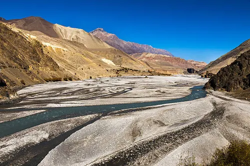
The Lower Mustang Muktinath Trek follows the ancient salt trade route up the Kali Gandaki Gorge — the world’s deepest river gorge — to the sacred pilgrimage temple of Muktinath (3,800m), revered equally by Hindus and Buddhists as one of the holiest sites in the Himalayas. Unlike Upper Mustang, this route requires no restricted-area permit and passes through the dramatic Mustang landscape of dry canyons, cliff-top villages, and apple orchards around Marpha and Tukuche, making it an excellent and accessible introduction to the Mustang region.
The Lower Mustang Muktinath Trek is an outstanding 10-day journey through the world’s deepest river gorge to one of the most sacred pilgrimage destinations in the Himalayan world. Trekking through the dramatic Kali Gandaki valley — flanked by the 8,000 m peaks of Dhaulagiri (8,167 m) and Annapurna (8,091 m) — this route combines extraordinary natural scenery with profound cultural and spiritual experience at its destination: the sacred temples and natural wonders of Muktinath at 3,800 m.
There is a part of Nepal that most people have only ever seen in photographs, that luminous stretch of trans Himalayan valley where the air is bone dry, the skies are impossibly blue, and ancient caravans once wound their way between Tibet and the subcontinent. The Jomsom Muktinath Trek takes you straight into that world. Over the course of ten days, you will travel from the subtropical riverbanks of Tatopani, with its natural hot springs and mango groves, all the way to Muktinath at 3,800 metres, one of the most sacred pilgrimage sites in all of Asia. Everything about this journey feels earned, from the wild Kali Gandaki gorge that ranks among the deepest on earth, to the moment you finally stand before Muktinath’s eternal flame and sacred water spouts.
This is a trek that rewards every kind of traveller. Seasoned trekkers will appreciate the dramatic topography, the genuine Thakali and Mustangi culture, and the wild swing in landscape from lush rhododendron forest to high desert moonscape. First-timers will find the well-serviced teahouse trail reassuring without ever being boring. There is genuine adventure here, in the wind that howls down the Kali Gandaki each afternoon, in the apple brandy warming your hands in Marpha, and in the silence that greets you above Kagbeni, where the paved road ends and the upper Mustang begins.
Unlike the Upper Mustang Trek, the Lower Mustang route does not require a restricted area permit, making it accessible to all trekkers with standard ACAP and TIMS permits. The trail is relatively gentle in gradient — it follows the Kali Gandaki River north through a sequence of culturally rich villages, including Tatopani (famous for its hot springs), Dana, Ghasa, and Marpha (the apple brandy capital of Nepal), before reaching Jomsom, the region’s administrative hub, and ultimately the sacred complex of Muktinath.
Muktinath (3,710 m) is extraordinary. Among the 108 spring-water spouts, a natural gas flame that burns from a rock crevice, and temples that are simultaneously sacred to Hinduism (as the abode of Lord Vishnu) and Buddhism (as one of the 24 Tantric places), the site draws Hindu pilgrims from across South Asia and Buddhist devotees from Tibet, Bhutan, and the Himalayan world. Arriving after days of walking through the dramatic gorge makes the experience all the more powerful.
The return from Muktinath to Jomsom offers the option of a short jeep or flight transfer to Pokhara, saving the knees on the long return walk and allowing time to explore Pokhara’s lakeside scene before returning to Kathmandu. This is an Easy-rated trek ideal for families, older trekkers, and those new to Nepal’s mountain trails.
Learn more on our Mustang Region page, and read our Annapurna Region and Trek Preparation Guide before you go.
Trek at a Glance
| Item | Details |
|---|---|
| Trip Duration | 10 Days / 9 Nights |
| Trek Start | Tatopani (1,190m) |
| Trek End | Muktinath (3,800m), then Pokhara |
| Maximum Altitude | 3,800m / 12,467ft (Muktinath Temple) |
| Trek Grade | Moderate |
| Best Season | March to May and September to November |
| Accommodation | Teahouses and Hotels along the route |
| Meals Included | Breakfast, Lunch, and Dinner (as per itinerary) |
| Transport | Private vehicle from Pokhara to Tatopani; flight or drive from Jomsom to Pokhara |
| Permits Required | TIMS Card, Annapurna Conservation Area Permit (ACAP) |
Practical Tips for Your Trek
Money and Payments
ATMs are available in Pokhara and Jomsom. There are no reliable cash machines beyond those points, so withdraw enough Nepali rupees in Pokhara before departure to cover personal expenses on the trail, including snacks, hot showers, device charging, and gratuities for your guide and porter. Teahouses do not accept cards.
Mobile Connectivity
NTC (Nepal Telecom) has the strongest signal coverage in the Mustang valley and works in most villages on this route, including Jomsom, Kagbeni, and Muktinath. Ncell coverage is patchier north of Beni. If you plan to stay connected, a local SIM bought in Pokhara or Kathmandu with a data plan is the most practical option.
Water and Hydration
Tap water and stream water on the trail should be treated before drinking. Most trekkers carry water purification tablets or a lightweight filter as backup. Teahouses will boil water on request for a small charge, and this is the easiest solution for most days. Staying well hydrated is particularly important above 3,000 metres, where altitude can amplify dehydration.
Responsible Trekking
The Annapurna Conservation Area is one of the most visited protected landscapes in Nepal and faces real pressure from trekking traffic. Carry a reusable water bottle and refuse plastic single-use water bottles where possible. Take all non-biodegradable waste out with you or deposit it at designated collection points. Stay on marked trails to avoid damaging fragile high-altitude vegetation. Respect religious sites by removing footwear before entering temple compounds and always walking clockwise around mani walls and chortens. Ask before photographing local people.
Tipping Guidelines
Tipping is not obligatory but is very much appreciated and forms an important part of your guide and porter’s income. As a general guideline, USD 10 to 15 per day for your guide and USD 6 to 8 per day for your porter is considered appropriate for a well-run trip. Tips are best given in cash at the end of the trek. If your guide and porter have genuinely made your journey better, a generous tip is the most direct way to show it.
- Visit Muktinath temple (3,800m), sacred to both Hindus and Tibetan Buddhists
- Walk the Kali Gandaki Gorge — the world’s deepest river gorge between Dhaulagiri and Annapurna
- Explore the apple orchard village of Marpha, famous for its brandy and traditional architecture
- No restricted-area permit required — accessible and affordable
- Dramatic landscape: dry ochre canyons and wind-sculpted cliffs on the edge of the Tibetan plateau
- Combines well with the Annapurna Circuit for an extended journey
Itinerary of Lower Mustang Muktinath Trek: Complete 10-Day Epic Trekking Experience in Nepa
Day 1: Drive Pokhara to Tatopani (1,190m)
Your journey begins early in Pokhara, that lakeside city at the foot of the Annapurna range, where the dhrupad of boatmen carries across Phewa Tal in the cool morning hours. Your private vehicle leaves before the city fully wakes, heading east along the Prithvi Highway before turning north into the Kali Gandaki corridor. The road hugs the river for much of the way, climbing past Beni and Baglung, winding through roadcuts in the hillside where waterfalls sometimes spray directly onto the windscreen during the monsoon months.
Tatopani itself sits at a bend in the Kali Gandaki where the river still carries some warmth from lower elevations. The name means simply hot water in Nepali, and the natural hot spring pools that bubble up beside the riverbank have been pulling weary trekkers off the trail for generations. After you check into your teahouse, the afternoon is yours to soak your muscles, sit with a pot of Nepali milk tea, and watch the river run jade-green between its grey boulder banks. Dinner in Tatopani tends to be hearty, the local teahouses producing dal bhat and Thakali-style mixed dishes that are already noticeably different from what you find in Pokhara. Sleep comes easily here, with the sound of the river doing half the work.
Duration
DriveActivity
TravelAccommodation
TeahouseMeals
L/DMax Altitude
1190mDay 2: Tatopani to Ghasa (2,010m)
Leaving Tatopani, the trail begins climbing almost immediately and does not let you forget it. The first hour involves a sustained ascent through terraced farmland and small settlements where women beat grain on flat rocks, and children eye your trekking poles with frank curiosity. The Kali Gandaki gorge, already formidable from the road, starts to reveal its true scale on foot. The walls on either side reach skyward in sheer faces of grey and ochre stone, and the river below sounds different here, more insistent, more compressed by the narrowing canyon.
The trail passes through Rupse Chhahara, where a multi-stage waterfall threads down a mossy cliff face just a few metres from the path. It is one of those moments that stop you mid-stride, the kind of spectacle that does not quite fit in a photograph but fixes itself perfectly in memory. Beyond the falls, the gradient eases slightly, and the landscape opens. Ghasa village announces itself with a long, flat main street and a row of stone-walled teahouses whose courtyards are strung with prayer flags. It marks the traditional entry into the Thakali region, and you can feel the cultural shift in the architecture, the menus, and the way the evening light sits on the mountains above the village.
Duration
5-6 hrsActivity
TrekkingAccommodation
TeahouseMeals
B/L/DMax Altitude
2010mDay 3: Ghasa to Lete (2,470m)
The stretch between Ghasa and Lete is one of the most varied on the entire route. You wake to the smell of juniper smoke drifting from kitchen fires and the sound of mules being loaded for a day’s carry. The trail threads through pine and rhododendron forest for long stretches, the tree cover filtering the early morning light into green and gold columns. In spring, the rhododendron blooms turn the hillside into something almost theatrical, reds and pinks splashed against the grey rock faces above.
The gorge here is at its most theatrical. The Kali Gandaki cuts between the Annapurna massif to the east and the Dhaulagiri massif to the west, creating the deepest valley on earth by some measures, with peaks on either side reaching above 8,000 metres. On a clear day, you can see both summits from the valley floor, which puts the scale of the place in perspective in a way that no altitude figure can. Lete is a quieter village than those before it, its stone houses grouped around a small square. The teahouses here are unpretentious and warm, the food simple but generous, and the night sky, once the village generator cuts at nine, is extraordinary.
Duration
4-5 hrsActivity
TrekkingAccommodation
TeahouseMeals
B/L/DMax Altitude
2470mDay 4: Lete to Marpha (2,670m)
Crossing into the true rain shadow of the Himalayas happens somewhere between Lete and Marpha, and the landscape makes the announcement loudly. The dense forest thins, the air loses its moisture, and the scrubby desert vegetation of the high Mustang starts to take over. The Kali Gandaki winds itself wide between gravel bars here, the braided channels running fast and shallow, and the wind that will define afternoon travel in this valley begins to make itself felt around noon.
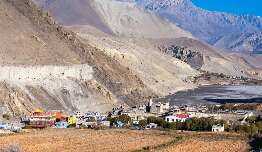
Marpha is the jewel of the Jomsom Muktinath trail, and most trekkers know it the moment they see it. The village is a labyrinth of cobbled alleyways between whitewashed stone houses, with a covered drainage channel running down the centre of the main lane and open rooftops strung with drying apples and apricots. Marpha sits at the heart of Nepal’s most productive apple-growing region, and the orchards that surround the village glow with fruit from September onwards. The local brandy and cider made from these apples are reason enough to build an extra hour into the afternoon schedule. Sit in one of the courtyard cafes, order a glass, and watch the afternoon light turn the walls of Dhaulagiri to amber.
Duration
4-5 hrsActivity
TrekkingAccommodation
TeahouseMeals
B/L/DMax Altitude
2670mDay 5: Marpha to Jomsom (2,720m)
The walk from Marpha to Jomsom is the shortest day on the trek by distance, but the wind that typically builds by mid-morning means it can feel longer than it looks on the map. The Kali Gandaki channelling effect turns the valley floor into something resembling a wind tunnel by ten or eleven o’clock, and the fine sand it carries stings any exposed skin. Trekkers who set off early arrive in Jomsom before the gusts reach full force, which is worth remembering when you are tempted to linger over a second cup of coffee in Marpha.
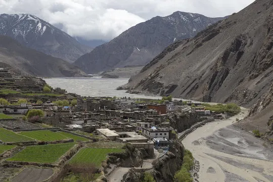
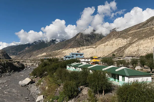
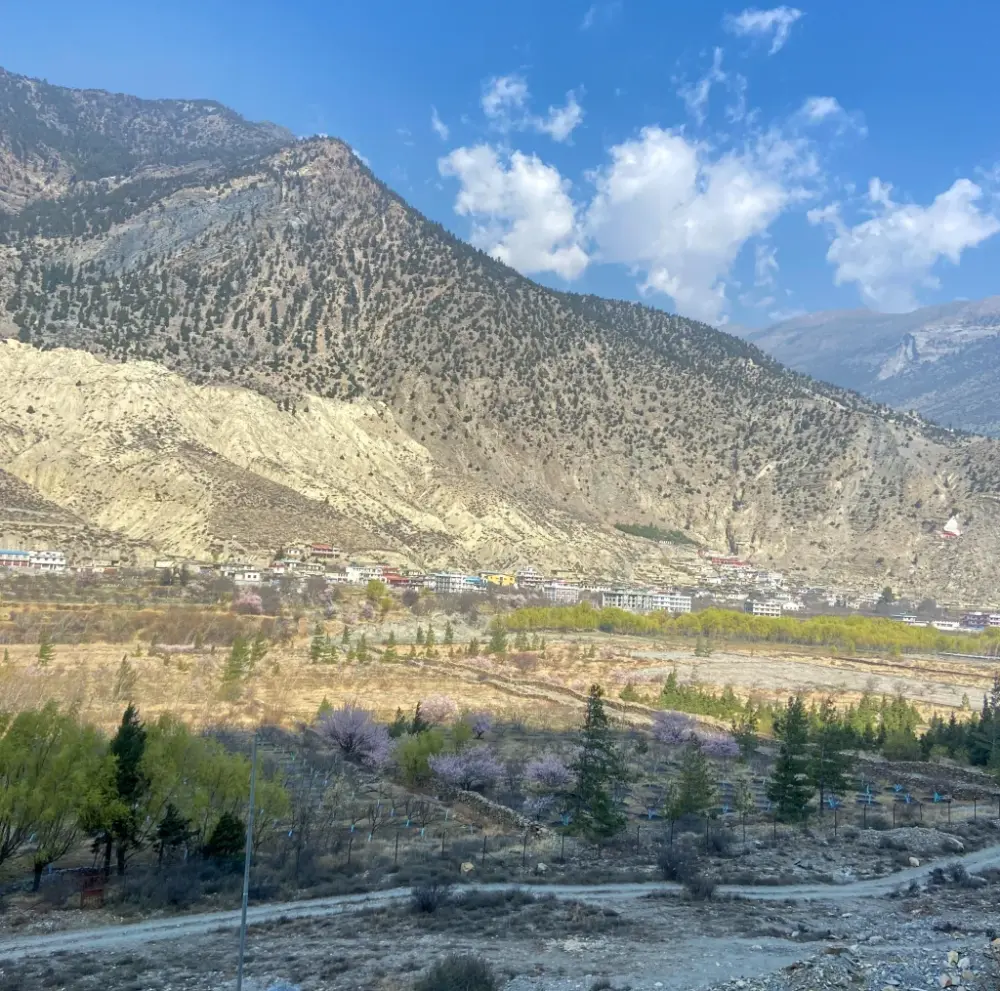
Jomsom is the administrative headquarters of Mustang District and the largest settlement on the trek, a functional town with banks, medical facilities, and a small airport. It sits at the confluence of the Kali Gandaki and the Panda Khola, and the landscape around it has a raw, almost Central Asian quality: bare ridgelines, eroded cliffs striped in red and brown, and the feeling of being at a geographical crossroads. Your accommodation in Jomsom is a step up from the teahouses of previous nights, with attached bathrooms in most guesthouses and reliable hot water. The evening meal is worth seeking out at one of the Thakali restaurants near the main bazaar, where the set plates of buckwheat bread, lentil soup, and fermented vegetables are prepared with a care that honours centuries of local culinary tradition.
Duration
2-3 hrsActivity
TrekkingAccommodation
HotelMeals
B/L/DMax Altitude
2720mDay 6: Jomsom to Kagbeni (2,810m)
The trail to Kagbeni follows the Kali Gandaki northward, and the landscape transitions with almost deliberate drama. Behind you is the valley you have been climbing through for five days. Ahead, the fortress-like ridgeline that marks the ancient border of Mustang, the medieval Lo kingdom that remained closed to outsiders until 1992. Kagbeni sits precisely at that threshold, a walled town of medieval Tibetan-influenced architecture rising above the confluence of the Kali Gandaki and Jhong Khola rivers.
The town itself is one of the most atmospheric on any trail in Nepal. The main entrance is still guarded by the ruins of a stone watchtower, and the narrow lanes inside tunnel between buildings so close overhead that they almost block the sky. Red ochre monasteries, prayer wheels that spin perpetually at corners, the smell of yak butter and incense from doorways left ajar: Kagbeni gives you the feeling of having stepped backward several centuries without any theatrical effort on its part. A checkpoint at the northern edge of town marks the boundary beyond which trekkers need the Upper Mustang permit, which makes it worth pausing at the mani walls and simply looking north at the forbidden plateau above.
Duration
3-4 hrsActivity
TrekkingAccommodation
TeahouseMeals
B/L/DMax Altitude
2810mDay 7: Kagbeni to Muktinath (3,800m)
This is the day the whole trek has been building toward, a long, steady climb from the medieval streets of Kagbeni up through the high Mustang plateau to one of the most sacred sites in the Hindu and Buddhist world. The trail leaves the Kali Gandaki behind, climbing through Khinga and Jharkot, both of which reward a slow walk-through with their ancient architecture and hilltop fortresses. The altitude starts to register more noticeably after 3,000 metres, and the pace naturally slows, but the scenery compensates generously, with panoramic views opening up across the Annapurna and Dhaulagiri ranges as you gain height.
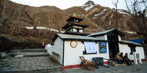
Muktinath Temple complex sits at 3,800 metres in a grove of poplar trees that seems almost improbable at this elevation, their leaves catching the thin Himalayan light and turning it golden in the afternoon. The site holds equal sanctity for Hindus, who revere it as one of the 108 Vishnu shrines of the Vaishnava tradition, and for Tibetan Buddhists, who venerate it as Chumig Gyatsa, the place of a hundred waters. The 108 sacred water spouts that ring the main temple compound have been flowing continuously for centuries, and pilgrims walk the circumambulation circuit with a devotion that is genuinely moving to witness. The eternal flame fed by natural gas seeping through rock inside one of the shrines makes the theological symbolism of earth, water, and fire feel very concrete. Spend the evening here quietly. Few places on the trail carry this much weight.
Duration
4-5 hrsActivity
TrekkingAccommodation
TeahouseMeals
B/L/DMax Altitude
3800mDay 8: Muktinath to Jomsom — Fly or Drive to Pokhara
Morning at Muktinath tends to be still and cold, the kind of cold that makes the hot water from the teahouse kitchen taste like a luxury. A final walk around the temple complex before the pilgrims arrive in numbers is one of the quieter pleasures of having slept here. The descent back to Jomsom follows the same trail you climbed and takes considerably less time going down, the views of the Dhaulagiri wall and the barren Mustang plateau behind you making the walk back feel like a different journey entirely.
From Jomsom, the return to Pokhara is either by the small mountain aircraft that run most mornings when the Jomsom wind allows, or by jeep down the dirt road that has replaced much of the old trekking trail on the southern half of the valley. The flight, when conditions permit, is extraordinary: sixteen minutes that cover what took five days on foot, with Dhaulagiri, Annapurna South, and the full arc of the Kali Gandaki corridor visible from the window. Landing at Pokhara airport feels like re-entering the modern world.
Your hotel for the night is in Pokhara city, and the evening is yours to rest, review the photographs, and reacquaint yourself with a restaurant menu that extends beyond dal bhat.
Duration
2 hrs + Flight/DriveActivity
TravelAccommodation
HotelMeals
B/LMax Altitude
820mDay 9: Pokhara Rest Day
Pokhara earns its reputation as Nepal’s leisure capital on days like this one. The city wraps itself around Phewa Lake with a particular ease, its lakeside promenade lined with cafes, bookshops, and gear stores that are equally useful for buying forgotten essentials and for simply sitting and watching the Annapurnas float above the far shore. After nine days on the trail, the simple act of choosing from a menu, ordering a coffee that arrives in a proper ceramic cup, and sitting with no particular schedule is a genuine pleasure.
The day invites exploration at whatever pace suits you. The World Peace Pagoda on the ridge south of the lake rewards the climb with the finest panoramic view of the Annapurna range available from a paved road. The Old Bazaar district to the north of the lake has a Newar-flavoured architecture quite different from the tourist strip and is worth a morning wander. The International Mountain Museum near Prithvi Chowk holds a collection of Himalayan climbing history that puts the peaks you have just walked beneath into a wider context. In the evening, the restaurant scene around Lakeside offers everything from Nepali thali to wood-fired pizza, and after nine days of teahouse eating, the variety alone is its own kind of celebration.
Duration
RestActivity
RestAccommodation
HotelMeals
BMax Altitude
820mDay 10: Final Departure to Kathmandu
The final morning in Pokhara has a particular quality that most trekkers notice: the mixture of genuine reluctance to leave and the quiet satisfaction of a journey completed. Breakfast is unhurried, the lakeside light at its clearest and most golden. Depending on your onward travel plans, the transfer to Kathmandu is either by the short domestic flight that delivers you over a ridge of green hills to the Kathmandu Valley in under half an hour or by tourist bus along the Prithvi Highway through a landscape of river gorges and terraced hillsides that takes the better part of a day.
Kathmandu receives you with its particular density of sound, smell, and colour. If your international departure is the following day, the city offers its own rich agenda: Thamel’s bookshops and craft stores, the temple squares of Durbar Marg, the stupas of Boudhanath or Swayambhunath for a quiet evening circumambulation. If you are connecting onward the same evening, the airport sits close enough to the hotel district to make a late afternoon arrival comfortable. Either way, the Jomsom Muktinath Trek delivers you back to the world with a full memory card, muscles that feel genuinely used, and the peculiar clarity of mind that only extended time in the mountains seems to produce.
Duration
DepartureActivity
TravelAccommodation
HotelMeals
BMax Altitude
1400mIncludes/Excludes
What's included?
- 9 nights accommodation (2 hotel Pokhara, 7 teahouse)
- All ground transport (Pokhara–Nayapul and return)
- All meals on trek
- Licensed English-speaking guide and porter
- ACAP permit and TIMS card
- First-aid kit and emergency protocols
What's not included?
- International airfare and Nepal visa fees
- Travel and medical insurance (recommended)
- Personal gear and clothing
- Tips for guide and porter
- Beverages and personal snacks
Lower Mustang Muktinath Trek: Complete 10-Day Epic Trekking Experience in Nepa Altitude Chart
Trip Information - Good to Know
Permits Required
The Lower Mustang Muktinath Trek does not require the restricted area permit needed for Upper Mustang. Only standard trekking permits apply:
1. Annapurna Conservation Area Permit (ACAP): NPR 3,000 per person. Covers the entire Kali Gandaki and Mustang region below the Kagbeni restricted area boundary. Included in the Green Horizon package.
2. TIMS Card: NPR 2,000 per person. Required for all organised trekking groups. Included in the package.
Both permits are checked at Tatopani, Ghasa, Jomsom, and Kagbeni. Our guide manages all permit documentation. Note: trekking north of Kagbeni into Upper Mustang requires the restricted area permit (USD 500), which is not included in this package.
Best Time to Go
Spring (March–May) and Autumn (September–November) are the best seasons. Spring brings warm temperatures and flowering vegetation in the lower Kali Gandaki valley. October and November offer excellent visibility and stable weather.
The lower sections of the Kali Gandaki valley (Tatopani, Dana, Ghasa) receive moderate monsoon rain (June–August) but remain trekable. The upper valley above Ghasa is in the rain shadow and stays largely dry. Winter (December–February) is cold but feasible with appropriate gear — overnight temperatures in Muktinath can drop to -10°C.
Difficulty Level
The Lower Mustang Muktinath Trek is rated Easy — the most accessible of the Mustang trekking options. The maximum altitude of 3,800 m is modest, and the ascent is gradual. Daily walking times average 4–6 hours on well-established, gently graded trails alongside the Kali Gandaki River.
No technical skills or prior high-altitude experience are required. This trek is suitable for older trekkers, families with children aged 12 and above, and first-time Nepal trekkers. The jeep and flight options on the return make it flexible and knee-friendly. Good walking shoes (not boots necessarily) and warm layers for the evenings are the main kit requirements.
Frequently Asked Questions
What makes Muktinath sacred?
Muktinath is one of the 108 Vishnu Divyadesams (sacred Vishnu temples) for Hindus and the site of Jwala Mai (eternal flame from natural gas) revered by Buddhists. Both traditions meet at this single pilgrimage point.
Do I need a special permit for this trek?
No — Lower Mustang and Muktinath do not require the expensive Upper Mustang Restricted Area Permit. Only the standard ACAP and TIMS are needed.
What is Marpha famous for?
Marpha is famous throughout Nepal for its apple orchards and apple products: fresh apples, apple juice, apple brandy (the local cider), and apple jam. The traditional Thakali stone architecture is also exceptionally well-preserved.
Can I extend this trek to Upper Mustang?
Yes — from Kagbeni you can continue north into Upper Mustang with the appropriate restricted-area permit. Green Horizon Tours can arrange the permit and guide upgrade in Jomsom.
Is the Kali Gandaki gorge the deepest in the world?
Yes — between the 8,000m+ peaks of Dhaulagiri and Annapurna, the Kali Gandaki drops over 5,500m in horizontal distance, qualifying as the world’s deepest gorge by most geographic measurements.
What is the wind like in the gorge?
The Kali Gandaki is famous for its powerful afternoon winds that blow north from midday. Trek early mornings are calm; afternoons are windy. This wind pattern drove the ancient salt trade — caravans travelled with the wind.
Trip Reviews
- Best Price Guarantee
- Secure & easy booking
- Easy trip date changes
- Discount for groups


How to book a trip?

make free inquiry

confirm the trip