

The Ultimate Guide to Langsisha Kharka: The Hidden Glacial Amphitheater of Langtang
The Langtang Valley has long been celebrated as one of Nepal’s most accessible yet visually stunning trekking destinations. Tucked away just north of Kathmandu, it offers an incredible mix of dense rhododendron forests, ancient Tamang culture, and dramatic alpine scenery. However, while the vast majority of trekkers consider Kyanjin Gompa (3,870m / 12,697ft) the final destination of their journey, a magnificent frontier lies further east—Langsisha Kharka (4,160m / 13,648ft).
For travelers who crave raw wilderness, untouched landscapes, and true mountain solitude, Langsisha Kharka is the ultimate hidden gem of the Langtang region. It is a vast, glacier-carved pastureland surrounded by colossal walls of rock and ice, serving as the gateway to challenging trekking peaks and technical mountaineering routes like Langsisha Ri (6,427m) and Dorje Lhakpa (6,966m).
Whether you are planning an extended day-hike from Kyanjin Gompa or embarking on a fully-fledged camping expedition toward the high passes, this comprehensive guide covers everything you need to know about exploring the wilderness of Langsisha Kharka.
What and Where is Langsisha Kharka?
Langsisha Kharka (also spelled Langshisha) is a high-altitude alpine meadow situated in the upper reaches of the Langtang Valley, within the boundaries of the Langtang National Park.
[Kathmandu] ──(Drive)──> [Syabrubesi] ──(Trek)──> [Lama Hotel] ──> [Kyanjin Gompa] ──> [Langsisha Kharka]
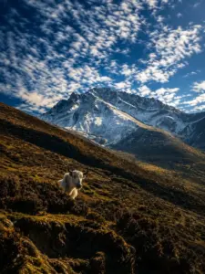
In the local Tibetan-linked dialects spoken by the Tamang and Sherpa communities of the valley, Kharka translates directly to “pasture” or “grazing land.” For generations, this remote valley floor has served as a summer grazing ground for yaks. Local herders drive their livestock up to these nutrient-rich alpine meadows when the winter snows melt, living in simple, temporary stone huts (Goths) scattered across the rocky terrain.
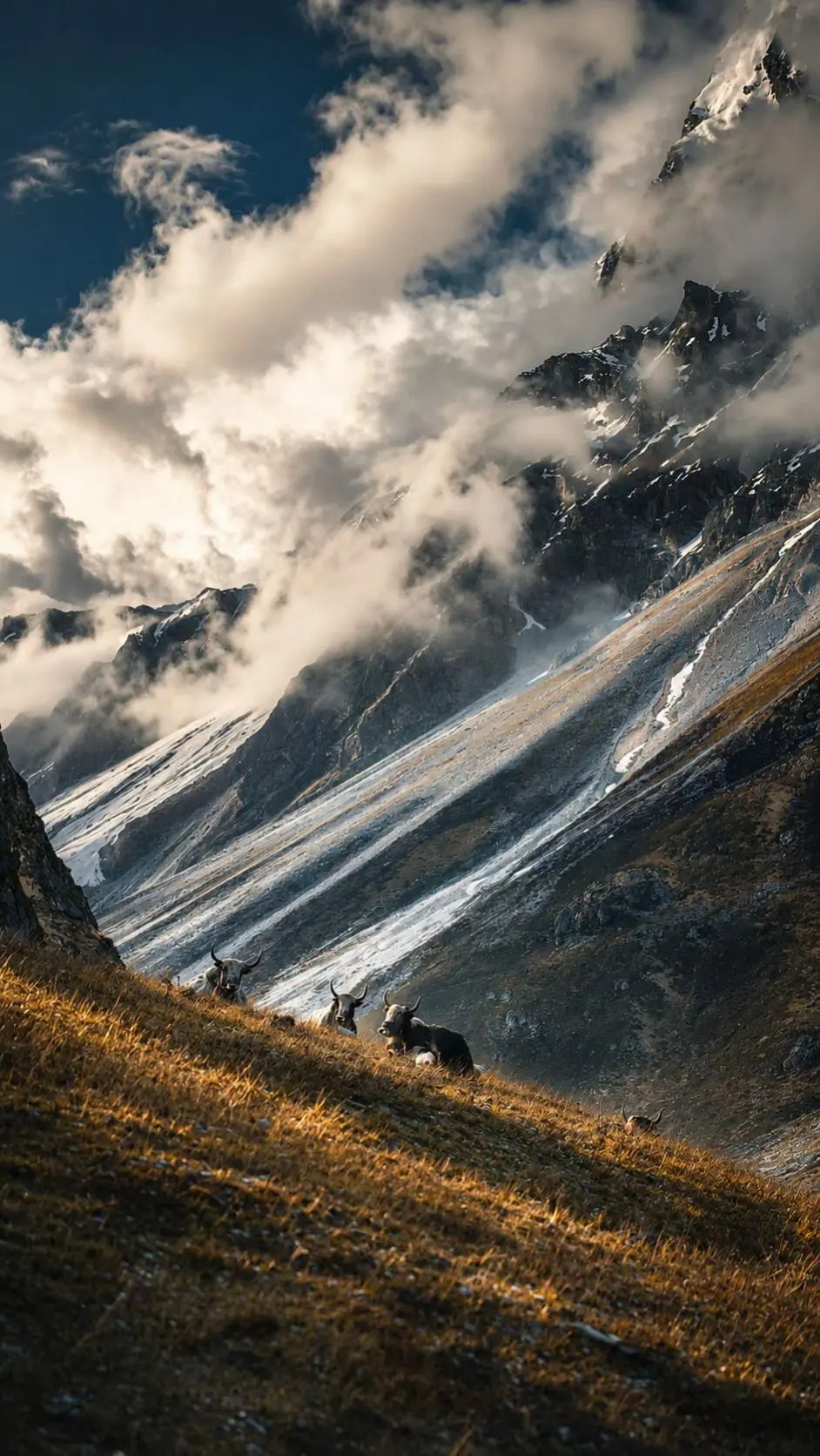
Geographically, Langsisha Kharka sits at an elevation of approximately 4,160 meters (13,648 feet). It marks the point where the main, U-shaped glacial valley of Langtang begins to branch into deep, wild amphitheaters dominated by massive glacial moraines and intersecting ice fields. Standing in the center of the Kharka, you are treated to a 360-degree theater of towering peaks, including Langshisha Ri, Pemthang Karpo Ri, Kanshurum, and the Jugal Himal extension.
Why You Should Add Langsisha Kharka to Your Langtang Itinerary
Most standard Langtang Valley itineraries allot one or two acclimatization days at Kyanjin Gompa. Typically, trekkers use this time to scale Kyanjin Ri (4,773m) or the more demanding Tserko Ri (4,984m). While these viewpoints offer breathtaking panoramic views from an elevated perspective, they can become crowded during peak seasons.
Here is why pushing eastward along the valley floor to Langsisha Kharka offers a completely different, deeply rewarding alternative:
1. Escape the Crowds and Find Solitude
While dozens of trekkers head up the switchbacks of Tserko Ri every morning, only a handful venture toward Langsisha Kharka. The trail immediately plunges you into a quiet, meditative wilderness where the only sounds are the rushing waters of the infant Langtang Khola, the whistling wind, and the occasional chime of a yak’s bell.
2. Witness Living Pastoral Culture
Langsisha Kharka is not a manufactured tourist destination; it is a functional, seasonal pastoral settlement. If you trek during the late spring or summer months, you will witness the traditional high-altitude lifestyle of the local herders. Watching a herd of yaks grazing against a backdrop of 6,000-meter ice walls is an unforgettable sight that connects you deeply to the living cultural heritage of the Himalayas.
3. A Paradise for Glacier Lovers
The hike to Langsisha Kharka brings you closer to the actual valley glaciers than almost any other trail in the region. As you near the pasture, you will see the dramatic terminus of the Langsisha Glacier and the massive lateral moraines carved out over millennia. The raw, debris-covered ice formations and the sound of shifting ice echoing off the rock faces provide an incredible sensory experience.
4. Breathtaking Low-Angle Mountain Views
Unlike the steep, vertical ascents of the nearby peaks, the walk to Langsisha Kharka follows a relatively gradual incline along the valley floor. This provides a unique, low-angle perspective of the mountains. Instead of looking down on the valley, you are standing directly at the feet of giants like Ganchenpo (6,378m) and Urkinmang (6,151m), making their vertical relief feel vastly more imposing.
The Myth of Langsisha Kharka: The Legend of the Red Ox
Like many landmarks in the sacred hidden valleys (Beyuls) of the Himalayas, Langsisha Kharka is steeped in rich spiritual mythology. Local elders tell a beautiful legend explaining how this remote pasture was discovered and named.
According to local folklore, centuries ago, a revered Buddhist lama living in Tibet lost a magnificent, sacred red ox from his herd. The ox wandered away, crossing the high, snow-bound mountain passes that separate Tibet from Nepal. The lama tracked the animal through the jagged peaks and down into an uncharted, pristine valley.
Finally, the lama discovered his ox resting at a vast, beautiful pastureland deep within the valley. However, shortly after being found, the sacred ox passed away at that very spot. The lama, recognizing the spiritual significance of the place, named the pasture Lang-sisa, which translates from the local dialect to “The Place Where the Ox Died.”
To honor the animal, the lama erected a large stone marker at the site. Today, trekkers can still find a prominent, historic rock structure in the pasture decorated with white prayer flags, which locals believe marks the final resting place of the legendary red ox. This myth adds an aura of ancient mysticism to the landscape, reminding travelers that they are walking through a valley deeply revered by its inhabitants.
Trail Description: Kyanjin Gompa to Langsisha Kharka
The journey to Langsisha Kharka is most commonly executed as a long, full-day side excursion from Kyanjin Gompa.
Quick Route Facts
-
Starting/Ending Point: Kyanjin Gompa (3,870m / 12,697ft)
-
Maximum Elevation: Langsisha Kharka (4,160m / 13,648ft)
-
Total Round-Trip Distance: Approximately 24 kilometers (15 miles)
-
Time Required: 8 to 10 hours round-trip (depending on your pace and fitness)
-
Terrain: Glacial valley floor, rocky paths, loose scree, sandy riverbeds, and open pastures.
Phase 1: Leaving Kyanjin Gompa and Entering the Upper Valley
The hike begins early in the morning from Kyanjin Gompa. Leaving the teahouses and the iconic local cheese factory behind, you head due east, following the wide, flat trail that runs parallel to the north bank of the Langtang Khola.
The initial stretch of the trail is incredibly pleasant. The valley floor here is wide and U-shaped—a classic textbook indicator of past glacial carving. As you walk, the massive bulk of Tserko Ri rises sharply to your left (north), while across the river to your right (south), the jagged ridges of Naya Kanga (5,844m) and Ganchenpo dominate the skyline.
The path passes through sparse vegetation, consisting mostly of low-lying juniper bushes, alpine shrubs, and hardy wildflowers if you are trekking in the spring. You will cross several small streams fed by the melting snows from the ridges above via simple wooden logs or stepping stones.
Phase 2: The Settlement of Numthang
After approximately 2 to 3 hours of steady walking, the trail brings you to Numthang (approx. 3,940m). Numthang is another seasonal herding settlement consisting of a few stone huts and walled pastures used to corral yaks overnight.
Numthang serves as an excellent spot to take a short break, hydrate, and enjoy a packed snack. The views from here open up dramatically toward the head of the valley. You can clearly see the distinct cone shape of Langshisha Ri standing sentinel in the distance. The trail beyond Numthang becomes noticeably wilder and more rugged, as the well-trodden paths start to give way to loose stones and glacial debris.
Phase 3: Navigating the Glacial Moraine and Debris
Leaving Numthang, the terrain transitions from flat, grassy plains to a more challenging landscape. You will need to navigate sections of lateral moraines—massive ridges of rock and soil pushed aside by ancient glaciers.
The trail here rises and falls gently as it crosses old landslide zones and boulder fields. Keeping a sharp eye out for stone cairns (small stacks of rocks left by herders and guides) is essential through this section, as the actual path can easily become obscured by shifting stones.
As you approach the confluence where the Langtang valley splits, you will cross areas of sandy riverbeds. Here, the Langtang Khola braids into multiple smaller streams rushing through the gravelly valley floor. The air becomes noticeably crisper and cooler as you draw closer to the massive ice sheets ahead.
Phase 4: Arrival at the Amphitheater of Langsisha Kharka
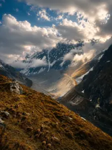
After 4 to 5 hours of trekking from Kyanjin Gompa, the valley opens up into the breathtaking expanse of Langsisha Kharka.
The arrival is nothing short of spectacular. You find yourself standing in a massive, flat, alpine meadow surrounded by a colossal amphitheater of snow, ice, and rock. The vertical walls of the surrounding mountains rise thousands of meters directly from the valley floor.
   [Langshisha Ri] (6,427m)          [Dorje Lhakpa] (6,966m)
         \                                  /
          \                                /
    ───────┴──────────────────────────────┴───────
         [ LANGSISHA KHARKA AMPHITHEATER ] (4,160m)
    ──────────────────────────────────────────────
                          ▲
                          │
                  (Trail from Numthang)
Take your time to explore the pasture. Locate the historic stone marker associated with the legend of the red ox, sit by the rushing glacial streams, and marvel at the towering summit of Langshisha Ri (6,427m) shooting into the sky directly to the north. To the southeast, the massive wall of Dorje Lhakpa displays its cascading icefalls and hanging glaciers.
Phase 5: The Return Journey to Kyanjin Gompa
Because there are no permanent tea houses or commercial lodges at Langsisha Kharka, you must turn around and retrace your steps back to Kyanjin Gompa for the evening.
While the return journey is predominantly downhill (dropping about 290 meters over 12 kilometers), do not underestimate it. After a long morning of walking at high altitude, fatigue can set in quickly. The rocky moraine sections require careful foot placement to avoid twisted ankles. Ensure you leave Langsisha Kharka no later than 1:00 PM or 2:00 PM to ensure you return to the comfort of your teahouse in Kyanjin Gompa well before sunset.
Complete 8-Day Langtang Valley & Langsisha Kharka Itinerary
To experience Langsisha Kharka safely and comfortably, it must be integrated into a well-structured itinerary that prioritizes gradual acclimatization. Below is a highly optimized, SEO-friendly 8-day itinerary starting and ending in Kathmandu.
Detailed Day-by-Day Breakdown
Day 01: Kathmandu to Syabrubesi (Drive)
-
Elevation Gain: +150 m (Starting from Kathmandu at 1,400m)
-
Highlights: Scenic mountain roads, views of Ganesh Himal, and crossing the Trishuli River.
Your journey begins with a drive out of the Kathmandu Valley. The route takes you along the winding mountain highways heading north, passing through historic towns like Trishuli Bazar and Dhunche. As you enter the Rasuwa District, you will pass through official checkpoints for the Langtang National Park. The drive offers glimpses of terraced farms, cascading waterfalls, and the distant, snow-capped peaks of the Ganesh Himal range. You overnight at Syabrubesi, a bustling trailhead town situated alongside the Bhote Koshi River.
Day 02: Syabrubesi to Lama Hotel
-
Elevation Gain: +920 m
-
Highlights: Walking along Langtang Khola, dense oak and rhododendron forests, suspension bridges.
This is your first official day on the trail. Leaving Syabrubesi, you cross a steel suspension bridge over the Bhote Koshi and follow the trail winding along the banks of the Langtang Khola. The path enters a dense, lush jungle canopy filled with oak, maple, bamboo, and rhododendron trees. This stretch of forest is a protected wildlife habitat; keep an eye out for gray langur monkeys, wild boars, and a vast array of colorful Himalayan birds. You will pass through small trailside settlements like Pairo and Bamboo before making a final, steep climb through the trees to reach Lama Hotel.
Day 03: Lama Hotel to Mundu via Langtang Village
-
Elevation Gain: +1,080 m
-
Highlights: Emerging above the tree line, dramatic views of Langtang Lirung, passing the memorial chorten at the new Langtang Village.
The trail continues its steady ascent through the river valley. As you gain altitude, the dense forest begins to thin, opening up into wider glacial terrain. After a steady climb of 3 to 4 hours, you reach Ghoda Tabela (3,020m), an ancient military outpost where the first clear, front-row views of Langtang Lirung (7,227m) reveal themselves.
Continuing upward, you pass traditional Tamang settlements, extensive prayer wheels, and long Mani walls carved with sacred Buddhist mantras. You will walk past the site of the old Langtang Village, which was tragically destroyed in the 2015 earthquake, and pass through the resilient new village constructed nearby. You spend the night at Mundu, a slightly higher, peaceful settlement that sets you up perfectly for a short walk the next morning.
Day 04: Mundu to Kyanjin Gompa
-
Elevation Gain: +320 m
-
Highlights: Massive Buddhist Mani walls, panoramic mountain amphitheater, visiting the ancient Kyanjin Monastery, and the yak cheese factory.
This is a shorter trekking day, designed intentionally to allow your body to adapt to the thin air above 3,500 meters. The trail from Mundu climbs gradually past high pasturelands and massive stone Mani structures. As you round a final bend in the valley floor, the stunning settlement of Kyanjin Gompa comes into view, nestled beneath the towering icefall walls of Langtang Lirung and Kimshung.
Arriving by lunchtime gives you a full afternoon to rest and explore. You can visit the historic Kyanjin Monastery, sample fresh yak cheese at the famous local government-supported factory, or take a gentle acclimatization walk up the lower ridges of Kyanjin Ri to watch the sunset over the valley.
Day 05: The Big Day – Kyanjin Gompa to Langsisha Kharka and Back
-
Elevation Gain/Loss: +290 m / -290 m (Peak altitude reached: 4,160m)
-
Highlights: Deep wilderness exploration, absolute solitude, unmatched views of Langshisha Ri and Dorje Lhakpa, and seeing the legendary stone.
This is the absolute highlight of your trek. You will wake up before dawn, pack a daypack with plenty of water, a hearty packed lunch, and warm layers, and head east into the uninhabited upper valley. Follow the trail description outlined in the previous section, taking time to savor the incredible peace of Numthang and the wild, raw beauty of the Langsisha pasture.
Spend an hour soaking in the immense glacial amphitheater at the Kharka, photographing the ice walls of Dorje Lhakpa, before turning back around. You will reach your cozy teahouse in Kyanjin Gompa by late afternoon, exhausted but deeply rewarded by one of the finest wilderness walks the Himalayas have to offer.
Day 06: Kyanjin Gompa to Lama Hotel
-
Elevation Loss: -1,400 m
-
Highlights: Long, easy descent, retracing steps through changing ecological zones, celebratory evening.
After the strenuous efforts of the previous day, your return journey begins. Because you are heading entirely downhill, your body will feel an incredible surge of energy as you descend into thicker, oxygen-rich air. You retrace your steps along the valley floor, passing back through Mundu, Langtang Village, and Ghoda Tabela. The rocky, high-altitude landscape quickly gives way once more to the comforting embrace of the green oak and rhododendron forests. You spend the night back at Lama Hotel.
Day 07: Lama Hotel to Syabrubesi
-
Elevation Loss: -920 m
-
Highlights: Final sights of the Langtang Khola, crossing majestic suspension bridges, and completing the loop.
Your final day of walking is a short, pleasant 4 to 5-hour descent back down to the trailhead. You follow the cascading waters of the Langtang Khola, enjoying the warmth of the lower altitude. Arriving back in Syabrubesi by early afternoon, you can finally enjoy a hot shower, toast a successful trek with your guide and porters, and rest your legs.
Day 08: Syabrubesi back to Kathmandu (Drive)
-
Elevation Loss: -150 m
-
Highlights: Final mountain views, returning to the vibrant energy of Kathmandu.
You board your private vehicle or local bus for the drive back to Kathmandu. As you wind along the mountain ridges and descend back into the capital city, you can look back toward the northern horizon, knowing you ventured far beyond the standard tourist trail into the deep, sacred wilderness of Langsisha.
Trekking Difficulty, Elevation Profile, and Safety Tips
Understanding the Difficulty Level
The standard Langtang Valley Trek is generally classified as a moderate trek, making it highly accessible to first-time trekkers and families with decent fitness. However, adding the full-day excursion to Langsisha Kharka increases the overall difficulty rating to moderate-challenging.
The challenge does not stem from technical climbing; rather, it is a matter of endurance and altitude. Walking 24 kilometers in a single day on rugged, rocky, unpaved terrain at an elevation consistently above 3,900 meters is physically taxing. It requires strong cardiovascular endurance, stable ankles, and mental resilience.
Elevation Profile & Acclimatization
Acclimatization is the single most critical factor for a safe trip. On this itinerary, you start at 1,550 meters and reach 4,160 meters within four days. To minimize the risk of Acute Mountain Sickness (AMS), keep these guidelines in mind:
-
The Golden Rule: Never rush your pace. Walk slowly and steadily (Bistari, Bistari in Nepali), keeping your heart rate stable.
-
Hydration: Drink between 3 to 4 liters of water daily. The dry, high-altitude air dehydrates your body rapidly, accelerating the onset of altitude headaches.
-
Incorporate the Acclimatization Day: Do not attempt to hike to Langsisha Kharka directly upon arriving from the lower villages. Ensure you have spent at least one full night at Kyanjin Gompa first.
-
Know the Symptoms: Familiarize yourself with early signs of AMS, including persistent headaches, dizziness, loss of appetite, nausea, and insomnia. If symptoms progress from mild to severe, the only solution is immediate descent to a lower altitude.
Best Seasons to Visit Langsisha Kharka
To experience the upper Langtang Valley in all its glory, timing your trek with the ideal weather windows is paramount. The region experiences two distinct peak trekking seasons.
[SPRING] Mar - May : Wildflowers, Melting Snow, Active Herders
[AUTUMN] Sep - Nov : Crystal Clear Skies, Stable Weather, Perfect Photography
1. The Autumn Season (September to November)
Autumn is universally considered the gold-standard season for trekking to Langsisha Kharka. Following the departure of the summer monsoon rains, the atmosphere is cleared of dust and haze, resulting in spectacularly sharp, crystal-clear panoramic views. Weather conditions are highly stable, with blue skies dominating the daytime. While temperatures drop significantly below freezing during the nights at Kyanjin Gompa, daytime walking conditions are absolutely perfect.
2. The Spring Season (March to May)
Spring is an equally magnificent time to visit, especially for nature lovers. The lower trails from Syabrubesi up to Ghoda Tabela burst into a vibrant display of colors as the rhododendron and orchid forests come into full bloom. As you move into the upper valley toward Langsisha, the winter snows are actively melting, filling the glacial rivers to their brims. This is also the time when herders begin moving their yak herds back up to the high pastures, allowing you to witness the living pastoral culture firsthand.
The Off-Peak Seasons (Winter and Monsoon)
-
The Monsoon (June to August): Heavy rains bring risks of landslides along the mountain driving routes, mud on the trails, and heavy cloud cover that completely obscures the mountain peaks. Leeches are prevalent in the forested zones.
-
The Winter (December to February): Extreme cold settles into the upper valley. Heavy snowfall can completely block the trail from Kyanjin Gompa to Langsisha Kharka, making navigation dangerous without specialized winter gear and wilderness navigation skills. Most seasonal herding huts are entirely abandoned during these months.
Required Permits and Logistics
Because Langsisha Kharka is situated within a protected national park and a border district, you must secure two distinct permits before starting your trek. These can be easily obtained at the official Department of Tourism counter in Kathmandu or directly at the park entry checkpoints along the drive to Dhunche.
1. Langtang National Park Entry Permit
This permit grants you legal access to the protected park boundaries. The funds generated go directly toward environmental conservation and community development initiatives within the park.
-
Cost for Foreign Nationals: NPR 3,000 per person (approx. USD $23–$25)
-
Cost for SAARC Nationals: NPR 1,500 per person
2. TIMS Card (Trekking Information Management System)
The TIMS card is a mandatory tracking permit implemented by the Nepal Tourism Board and the Trekking Agencies Association of Nepal (TAAN) to ensure the safety and security of trekkers across the country.
-
Cost: NPR 2,000 per person (approx. USD $15–$17)
Important Regulatory Note: Nepal updates its independent trekking regulations regularly. It is highly recommended to engage a licensed local guide through an authorized trekking agency. A professional guide ensures seamless navigation through the trail’s remote moraine sections and acts as a vital safety asset in high-altitude environments.
What to Pack for the Langsisha Excursion
Since the journey to Langsisha Kharka is executed as a long day-hike away from established teahouses, packing a well-curated daypack is essential. While your heavy duffel bag can stay safely at your lodge in Kyanjin Gompa, ensure your daypack contains the following items:
Essential Gear & Clothing Layers
-
Insulated Layer: A high-quality down jacket or thick fleece. The wind sweeping off the Langsisha Glacier can cause temperatures to plummet instantly when you stop moving.
-
Windproof/Waterproof Shell: A breathable jacket to protect against unexpected alpine showers or biting valley winds.
-
Sturdy Trekking Boots: Ankle-supportive, broken-in hiking boots with deep tread are non-negotiable for navigating loose moraine stones and boulder fields.
-
Trekking Poles: Highly recommended to reduce the impact on your knees during the long 24km round-trip and provide stability on uneven ground.
Hydration and Sustenance
-
Water Purification: Two 1-liter water bottles equipped with purification tablets or an integrated filtration system. Avoid buying single-use plastic water bottles in the national park to protect the environment.
-
Packed Lunch and Snacks: Request your teahouse host in Kyanjin Gompa to prepare a packed lunch (such as fried rice, boiled eggs, or Tibetan bread) the night before. Pack extra high-energy snacks like energy bars, nuts, chocolates, and electrolyte powders.
Miscellaneous Protection
-
Sun Protection: High-SPF sunscreen, polarized sunglasses, and a wide-brimmed hat. UV radiation increases significantly at high altitudes.
-
Navigation/Illumination: A reliable headlamp with extra batteries (in case your return journey extends past dusk) and a basic map or offline GPS route loaded on your phone.
Practical Comparison: Tserko Ri vs. Langsisha Kharka
If your time in Kyanjin Gompa is limited to a single acclimatization day, you might find yourself choosing between the climb up to Tserko Ri or the wilderness walk to Langsisha Kharka. Both are phenomenal options, but they cater to very different preferences. Use the comparison table below to decide which adventure aligns best with your trekking style:
Frequently Asked Questions (FAQs) about Langsisha Kharka
1. Can I stay overnight at Langsisha Kharka?
There are no commercial teahouses, lodges, or hotels at Langsisha Kharka. The area consists entirely of seasonal stone huts used by herders. If you wish to stay overnight, you must organize a fully self-sustained camping expedition complete with tents, sleeping pads, a kitchen crew, and all necessary food supplies. Otherwise, it must be completed as a day-hike returning to Kyanjin Gompa.
2. Is there mobile network coverage or Wi-Fi at Langsisha Kharka?
No. While you can occasionally find weak mobile network signals (Ncell/Nepal Telecom) or paid satellite Wi-Fi services in the main hub of Kyanjin Gompa, all connectivity drops completely within an hour of walking eastward toward Langsisha. Prepare to be entirely offline during this excursion.
3. Can a beginner trekker complete the walk to Langsisha Kharka?
Yes, provided they possess a solid baseline of physical fitness and have spent a minimum of 24 to 48 hours acclimatizing at the altitude of Kyanjin Gompa. The trail itself is not technically demanding or steep, but the sheer distance (24km round-trip) requires good stamina.
4. Are there any water sources along the trail?
You will walk alongside the Langtang Khola and pass numerous freshwater glacial streams. However, you should never drink unpurified water directly from the trail, as upstream pasturelands are used by livestock. Always use water purification tablets or a portable filtration device.
5. What should I do if it starts snowing while I am at the Kharka?
Weather patterns in the high Himalayas can shift rapidly during the afternoon. If clouds begin to build or light snow starts to fall, do not linger at the pasture. Immediately begin your return journey toward Kyanjin Gompa. The trail through the moraine sections can become hazardous and difficult to navigate if covered in fresh snow.
Conclusion: Venture Beyond the Ordinary
The Langtang Valley Trek is undeniably an incredible adventure, but extending your journey past the classic boundary of Kyanjin Gompa into the wilderness of Langsisha Kharka transforms a great trek into an extraordinary, deeply personal journey.
It is a place where nature presents itself in its rawest, most unfiltered form—unspoiled by commercialization, wrapped in ancient folklore, and guarded by an amphitheater of eternal ice. As you stand by the historic red ox monument, surrounded by towering peaks and the vast silence of the upper valley, you will realize that the true spirit of the Himalayas is always found just a little further down the trail.
Pack your bags, respect the local culture, leave no trace behind, and prepare to discover one of the finest hidden frontiers that Nepal has to offer!


How to book a trip?

make free inquiry

confirm the trip